You are here: Home > Network List > TA - USArray Transportable Network (new EarthScope stations) Stations List
> Station Q24A Divide, CO, USA > Earthquake Result Viewer
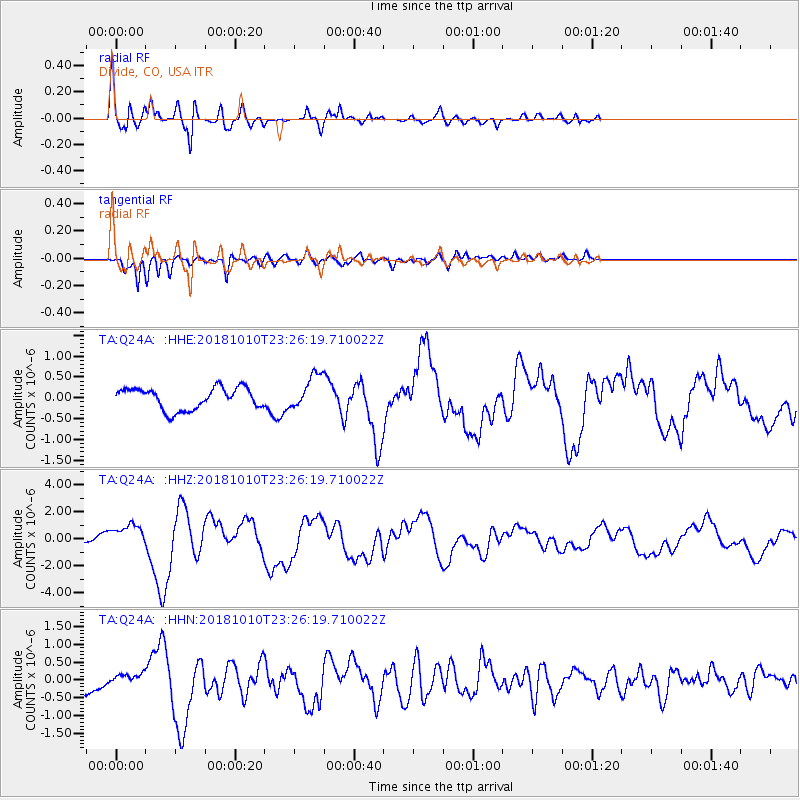
Q24A Divide, CO, USA - Earthquake Result Viewer

| Earthquake location: |
Kuril Islands |
| Earthquake latitude/longitude: |
49.1/156.4 |
| Earthquake time(UTC): |
2018/10/10 (283) 23:16:04 GMT |
| Earthquake Depth: |
33 km |
| Earthquake Magnitude: |
6.8 Mi |
| Earthquake Catalog/Contributor: |
NEIC PDE/at |
|
| Network: |
TA USArray Transportable Network (new EarthScope stations) |
| Station: |
Q24A Divide, CO, USA |
| Lat/Lon: |
38.96 N/105.15 W |
| Elevation: |
2775 m |
|
| Distance: |
66.6 deg |
| Az: |
57.147 deg |
| Baz: |
314.909 deg |
| Ray Param: |
0.057437845 |
| Estimated Moho Depth: |
23.25 km |
| Estimated Crust Vp/Vs: |
1.77 |
| Assumed Crust Vp: |
6.159 km/s |
| Estimated Crust Vs: |
3.475 km/s |
| Estimated Crust Poisson's Ratio: |
0.27 |
|
| Radial Match: |
87.87981 % |
| Radial Bump: |
400 |
| Transverse Match: |
84.49421 % |
| Transverse Bump: |
366 |
| SOD ConfigId: |
13570011 |
| Insert Time: |
2019-05-01 11:51:47.907 +0000 |
| GWidth: |
2.5 |
| Max Bumps: |
400 |
| Tol: |
0.001 |
|
Signal To Noise
| Channel | StoN | STA | LTA |
| TA:Q24A: :HHZ:20181010T23:26:19.710022Z | 2.646556 | 9.354194E-7 | 3.534478E-7 |
| TA:Q24A: :HHN:20181010T23:26:19.710022Z | 0.58248127 | 1.5689724E-7 | 2.6936016E-7 |
| TA:Q24A: :HHE:20181010T23:26:19.710022Z | 1.77499 | 4.6055732E-7 | 2.5947037E-7 |
| Arrivals |
| Ps | 3.0 SECOND |
| PpPs | 10 SECOND |
| PsPs/PpSs | 13 SECOND |


