You are here: Home > Network List > UO - University of Oregon Regional Network Stations List
> Station CHIL Chiloquin, OR, USA > Earthquake Result Viewer
CHIL Chiloquin, OR, USA - Earthquake Result Viewer
| Earthquake location: |
Kuril Islands |
| Earthquake latitude/longitude: |
49.1/156.4 |
| Earthquake time(UTC): |
2018/10/10 (283) 23:16:04 GMT |
| Earthquake Depth: |
33 km |
| Earthquake Magnitude: |
6.8 Mi |
| Earthquake Catalog/Contributor: |
NEIC PDE/at |
|
| Network: |
UO University of Oregon Regional Network |
| Station: |
CHIL Chiloquin, OR, USA |
| Lat/Lon: |
42.62 N/121.75 W |
| Elevation: |
1315 m |
|
| Distance: |
54.7 deg |
| Az: |
63.481 deg |
| Baz: |
307.174 deg |
| Ray Param: |
0.06519787 |
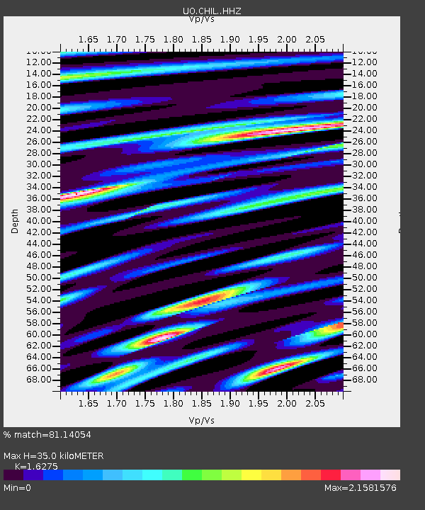
| Estimated Moho Depth: |
35.0 km |
| Estimated Crust Vp/Vs: |
1.63 |
| Assumed Crust Vp: |
6.597 km/s |
| Estimated Crust Vs: |
4.054 km/s |
| Estimated Crust Poisson's Ratio: |
0.20 |
|
| Radial Match: |
81.14054 % |
| Radial Bump: |
400 |
| Transverse Match: |
69.86204 % |
| Transverse Bump: |
400 |
| SOD ConfigId: |
13570011 |
| Insert Time: |
2019-05-01 11:52:20.168 +0000 |
| GWidth: |
2.5 |
| Max Bumps: |
400 |
| Tol: |
0.001 |
|

Signal To Noise
| Channel | StoN | STA | LTA |
| UO:CHIL: :HHZ:20181010T23:24:58.978027Z | 1.7516675 | 7.6295163E-7 | 4.3555735E-7 |
| UO:CHIL: :HHN:20181010T23:24:58.978027Z | 0.6324921 | 3.5821182E-7 | 5.6634985E-7 |
| UO:CHIL: :HHE:20181010T23:24:58.978027Z | 1.639706 | 1.0932788E-6 | 6.6675295E-7 |
| Arrivals |
| Ps | 3.5 SECOND |
| PpPs | 13 SECOND |
| PsPs/PpSs | 17 SECOND |


