You are here: Home > Network List > UW - Pacific Northwest Regional Seismic Network Stations List
> Station FISH Seaside, OR, USA > Earthquake Result Viewer
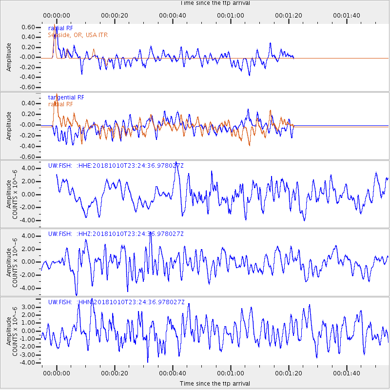
FISH Seaside, OR, USA - Earthquake Result Viewer
*The percent match for this event was below the threshold and hence no stack was calculated.
| Earthquake location: |
Kuril Islands |
| Earthquake latitude/longitude: |
49.1/156.4 |
| Earthquake time(UTC): |
2018/10/10 (283) 23:16:04 GMT |
| Earthquake Depth: |
33 km |
| Earthquake Magnitude: |
6.8 Mi |
| Earthquake Catalog/Contributor: |
NEIC PDE/at |
|
| Network: |
UW Pacific Northwest Regional Seismic Network |
| Station: |
FISH Seaside, OR, USA |
| Lat/Lon: |
45.93 N/123.56 W |
| Elevation: |
325 m |
|
| Distance: |
51.8 deg |
| Az: |
61.084 deg |
| Baz: |
304.482 deg |
| Ray Param: |
$rayparam |
*The percent match for this event was below the threshold and hence was not used in the summary stack. |
|
| Radial Match: |
75.11772 % |
| Radial Bump: |
400 |
| Transverse Match: |
68.9711 % |
| Transverse Bump: |
400 |
| SOD ConfigId: |
13570011 |
| Insert Time: |
2019-05-01 11:52:31.635 +0000 |
| GWidth: |
2.5 |
| Max Bumps: |
400 |
| Tol: |
0.001 |
|
Signal To Noise
| Channel | StoN | STA | LTA |
| UW:FISH: :HHZ:20181010T23:24:36.978027Z | 1.1868997 | 9.05081E-7 | 7.6255895E-7 |
| UW:FISH: :HHN:20181010T23:24:36.978027Z | 1.6953235 | 1.4317588E-6 | 8.445343E-7 |
| UW:FISH: :HHE:20181010T23:24:36.978027Z | 0.8520117 | 1.381821E-6 | 1.6218335E-6 |
| Arrivals |
| Ps | |
| PpPs | |
| PsPs/PpSs | |


