You are here: Home > Network List > WY - Yellowstone Wyoming Seismic Network Stations List
> Station YNE Northeast Entrance, YNP, WY, USA > Earthquake Result Viewer
YNE Northeast Entrance, YNP, WY, USA - Earthquake Result Viewer
| Earthquake location: |
Kuril Islands |
| Earthquake latitude/longitude: |
49.1/156.4 |
| Earthquake time(UTC): |
2018/10/10 (283) 23:16:04 GMT |
| Earthquake Depth: |
33 km |
| Earthquake Magnitude: |
6.8 Mi |
| Earthquake Catalog/Contributor: |
NEIC PDE/at |
|
| Network: |
WY Yellowstone Wyoming Seismic Network |
| Station: |
YNE Northeast Entrance, YNP, WY, USA |
| Lat/Lon: |
45.01 N/110.01 W |
| Elevation: |
2343 m |
|
| Distance: |
59.9 deg |
| Az: |
54.946 deg |
| Baz: |
310.672 deg |
| Ray Param: |
0.061849825 |
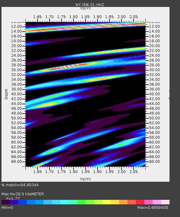
| Estimated Moho Depth: |
28.5 km |
| Estimated Crust Vp/Vs: |
1.77 |
| Assumed Crust Vp: |
6.35 km/s |
| Estimated Crust Vs: |
3.588 km/s |
| Estimated Crust Poisson's Ratio: |
0.27 |
|
| Radial Match: |
84.90344 % |
| Radial Bump: |
400 |
| Transverse Match: |
82.74331 % |
| Transverse Bump: |
400 |
| SOD ConfigId: |
13570011 |
| Insert Time: |
2019-05-01 11:53:04.961 +0000 |
| GWidth: |
2.5 |
| Max Bumps: |
400 |
| Tol: |
0.001 |
|

Signal To Noise
| Channel | StoN | STA | LTA |
| WY:YNE:01:HHZ:20181010T23:25:34.929993Z | 1.2433982 | 2.3922327E-8 | 1.9239474E-8 |
| WY:YNE:01:HHN:20181010T23:25:34.929993Z | 0.4902473 | 7.497798E-9 | 1.529391E-8 |
| WY:YNE:01:HHE:20181010T23:25:34.929993Z | 1.029083 | 1.0251328E-8 | 9.961614E-9 |
| Arrivals |
| Ps | 3.6 SECOND |
| PpPs | 12 SECOND |
| PsPs/PpSs | 15 SECOND |


