You are here: Home > Network List > XU16 - USGS NEHRP Proposal 2016-2018 - Greeley, CO Stations List
> Station GR02 Grover West, CO, USA > Earthquake Result Viewer
GR02 Grover West, CO, USA - Earthquake Result Viewer
| Earthquake location: |
Kuril Islands |
| Earthquake latitude/longitude: |
49.1/156.4 |
| Earthquake time(UTC): |
2018/10/10 (283) 23:16:04 GMT |
| Earthquake Depth: |
33 km |
| Earthquake Magnitude: |
6.8 Mi |
| Earthquake Catalog/Contributor: |
NEIC PDE/at |
|
| Network: |
XU USGS NEHRP Proposal 2016-2018 - Greeley, CO |
| Station: |
GR02 Grover West, CO, USA |
| Lat/Lon: |
40.89 N/104.35 W |
| Elevation: |
1576 m |
|
| Distance: |
65.7 deg |
| Az: |
55.18 deg |
| Baz: |
314.623 deg |
| Ray Param: |
0.058044285 |
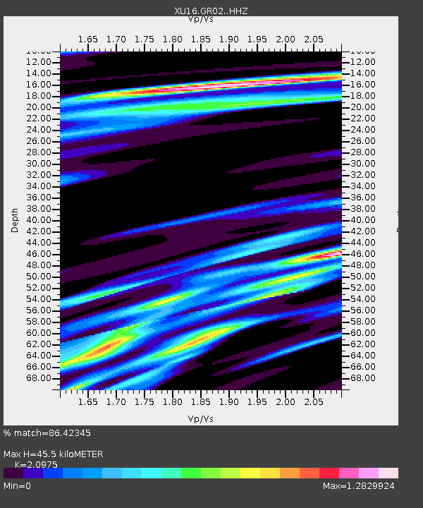
| Estimated Moho Depth: |
45.5 km |
| Estimated Crust Vp/Vs: |
2.10 |
| Assumed Crust Vp: |
6.306 km/s |
| Estimated Crust Vs: |
3.006 km/s |
| Estimated Crust Poisson's Ratio: |
0.35 |
|
| Radial Match: |
86.42345 % |
| Radial Bump: |
400 |
| Transverse Match: |
83.5781 % |
| Transverse Bump: |
400 |
| SOD ConfigId: |
13570011 |
| Insert Time: |
2019-05-01 11:53:13.933 +0000 |
| GWidth: |
2.5 |
| Max Bumps: |
400 |
| Tol: |
0.001 |
|

Signal To Noise
| Channel | StoN | STA | LTA |
| XU:GR02: :HHZ:20181010T23:26:13.754028Z | 1.6331987 | 1.364148E-6 | 8.352615E-7 |
| XU:GR02: :HH1:20181010T23:26:13.754028Z | 1.0541906 | 4.2602016E-7 | 4.041206E-7 |
| XU:GR02: :HH2:20181010T23:26:13.754028Z | 1.0859221 | 8.3061036E-7 | 7.648895E-7 |
| Arrivals |
| Ps | 8.2 SECOND |
| PpPs | 22 SECOND |
| PsPs/PpSs | 30 SECOND |


