You are here: Home > Network List > TA - USArray Transportable Network (new EarthScope stations) Stations List
> Station I14A Mackay, ID, USA > Earthquake Result Viewer
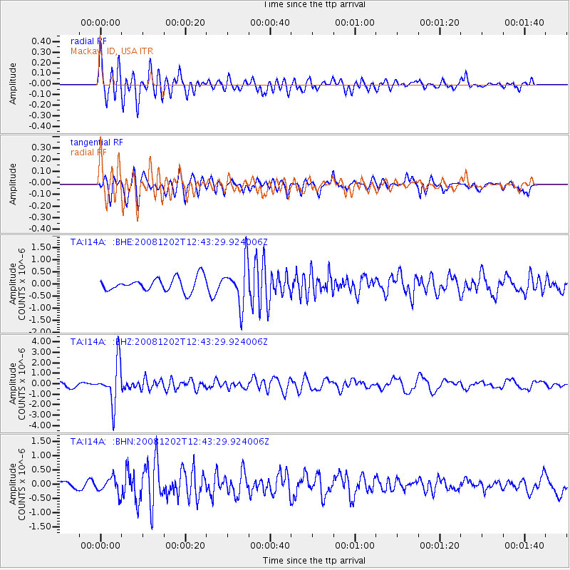
I14A Mackay, ID, USA - Earthquake Result Viewer
*The percent match for this event was below the threshold and hence no stack was calculated.
| Earthquake location: |
Mariana Islands |
| Earthquake latitude/longitude: |
19.1/145.8 |
| Earthquake time(UTC): |
2008/12/02 (337) 12:31:43 GMT |
| Earthquake Depth: |
137 km |
| Earthquake Magnitude: |
5.9 MB, 5.9 MW, 5.9 MW |
| Earthquake Catalog/Contributor: |
WHDF/NEIC |
|
| Network: |
TA USArray Transportable Network (new EarthScope stations) |
| Station: |
I14A Mackay, ID, USA |
| Lat/Lon: |
43.93 N/113.45 W |
| Elevation: |
1897 m |
|
| Distance: |
84.4 deg |
| Az: |
45.487 deg |
| Baz: |
291.055 deg |
| Ray Param: |
$rayparam |
*The percent match for this event was below the threshold and hence was not used in the summary stack. |
|
| Radial Match: |
68.4832 % |
| Radial Bump: |
400 |
| Transverse Match: |
75.27635 % |
| Transverse Bump: |
400 |
| SOD ConfigId: |
2658 |
| Insert Time: |
2010-03-06 16:45:27.575 +0000 |
| GWidth: |
2.5 |
| Max Bumps: |
400 |
| Tol: |
0.001 |
|
Signal To Noise
| Channel | StoN | STA | LTA |
| TA:I14A: :BHZ:20081202T12:43:29.924006Z | 7.906128 | 2.0000703E-6 | 2.529772E-7 |
| TA:I14A: :BHN:20081202T12:43:29.924006Z | 2.0925045 | 2.825538E-7 | 1.350314E-7 |
| TA:I14A: :BHE:20081202T12:43:29.924006Z | 3.162672 | 8.849306E-7 | 2.7980474E-7 |
| Arrivals |
| Ps | |
| PpPs | |
| PsPs/PpSs | |


