You are here: Home > Network List > TA - USArray Transportable Network (new EarthScope stations) Stations List
> Station I14A Mackay, ID, USA > Earthquake Result Viewer
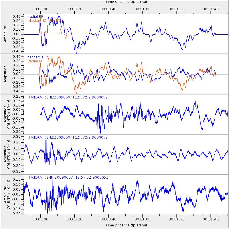
I14A Mackay, ID, USA - Earthquake Result Viewer
*The percent match for this event was below the threshold and hence no stack was calculated.
| Earthquake location: |
South Of Fiji Islands |
| Earthquake latitude/longitude: |
-22.0/-179.6 |
| Earthquake time(UTC): |
2009/06/07 (158) 12:46:30 GMT |
| Earthquake Depth: |
590 km |
| Earthquake Magnitude: |
5.5 MW, 5.1 MB |
| Earthquake Catalog/Contributor: |
WHDF/NEIC |
|
| Network: |
TA USArray Transportable Network (new EarthScope stations) |
| Station: |
I14A Mackay, ID, USA |
| Lat/Lon: |
43.93 N/113.45 W |
| Elevation: |
1897 m |
|
| Distance: |
89.2 deg |
| Az: |
41.36 deg |
| Baz: |
238.053 deg |
| Ray Param: |
$rayparam |
*The percent match for this event was below the threshold and hence was not used in the summary stack. |
|
| Radial Match: |
55.9635 % |
| Radial Bump: |
400 |
| Transverse Match: |
55.41875 % |
| Transverse Bump: |
400 |
| SOD ConfigId: |
2648 |
| Insert Time: |
2010-03-06 16:45:28.545 +0000 |
| GWidth: |
2.5 |
| Max Bumps: |
400 |
| Tol: |
0.001 |
|
Signal To Noise
| Channel | StoN | STA | LTA |
| TA:I14A: :BHZ:20090607T12:57:52.900005Z | 1.3783319 | 9.8985055E-8 | 7.18151E-8 |
| TA:I14A: :BHN:20090607T12:57:52.900005Z | 1.6051918 | 9.3209785E-8 | 5.8067695E-8 |
| TA:I14A: :BHE:20090607T12:57:52.900005Z | 2.16772 | 9.230988E-8 | 4.2583856E-8 |
| Arrivals |
| Ps | |
| PpPs | |
| PsPs/PpSs | |


