You are here: Home > Network List > TA - USArray Transportable Network (new EarthScope stations) Stations List
> Station J26L Joseph Creek, AK, USA > Earthquake Result Viewer
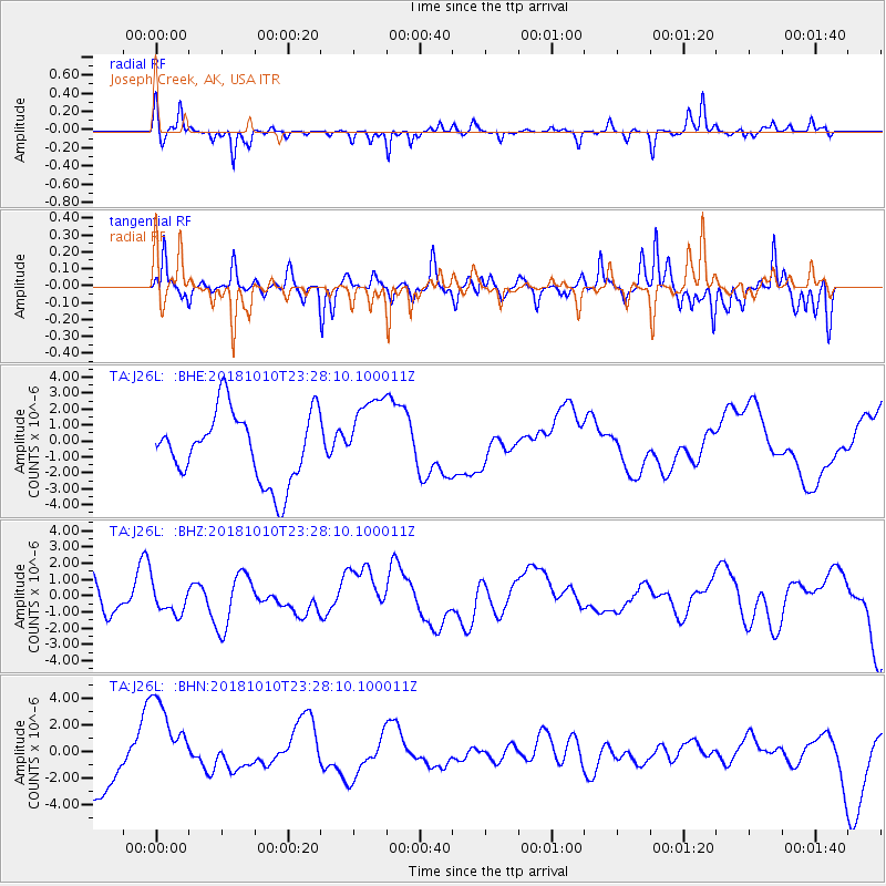
J26L Joseph Creek, AK, USA - Earthquake Result Viewer
*The percent match for this event was below the threshold and hence no stack was calculated.
| Earthquake location: |
Kuril Islands |
| Earthquake latitude/longitude: |
49.2/156.3 |
| Earthquake time(UTC): |
2018/10/10 (283) 23:21:50 GMT |
| Earthquake Depth: |
10 km |
| Earthquake Magnitude: |
5.5 mb |
| Earthquake Catalog/Contributor: |
NEIC PDE/us |
|
| Network: |
TA USArray Transportable Network (new EarthScope stations) |
| Station: |
J26L Joseph Creek, AK, USA |
| Lat/Lon: |
64.50 N/143.56 W |
| Elevation: |
1144 m |
|
| Distance: |
34.7 deg |
| Az: |
41.211 deg |
| Baz: |
273.267 deg |
| Ray Param: |
$rayparam |
*The percent match for this event was below the threshold and hence was not used in the summary stack. |
|
| Radial Match: |
49.559772 % |
| Radial Bump: |
225 |
| Transverse Match: |
42.217545 % |
| Transverse Bump: |
277 |
| SOD ConfigId: |
13570011 |
| Insert Time: |
2019-05-01 12:00:44.398 +0000 |
| GWidth: |
2.5 |
| Max Bumps: |
400 |
| Tol: |
0.001 |
|
Signal To Noise
| Channel | StoN | STA | LTA |
| TA:J26L: :BHZ:20181010T23:28:10.100011Z | 0.7741725 | 8.3817116E-7 | 1.0826672E-6 |
| TA:J26L: :BHN:20181010T23:28:10.100011Z | 1.1991154 | 3.279147E-6 | 2.7346384E-6 |
| TA:J26L: :BHE:20181010T23:28:10.100011Z | 1.1554469 | 2.5070756E-6 | 2.1697886E-6 |
| Arrivals |
| Ps | |
| PpPs | |
| PsPs/PpSs | |


