You are here: Home > Network List > TA - USArray Transportable Network (new EarthScope stations) Stations List
> Station I14A Mackay, ID, USA > Earthquake Result Viewer
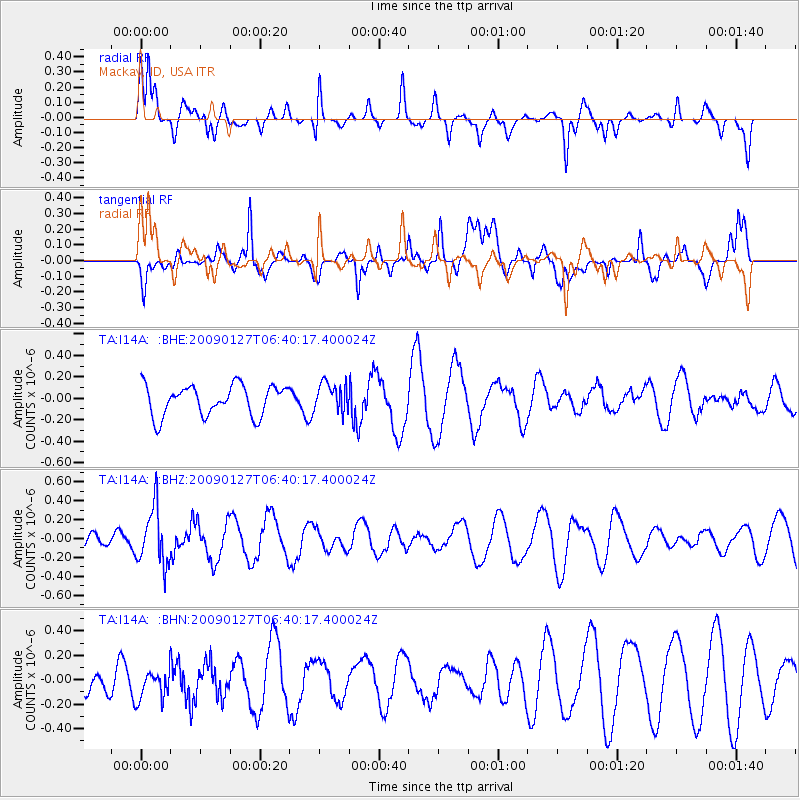
I14A Mackay, ID, USA - Earthquake Result Viewer
*The percent match for this event was below the threshold and hence no stack was calculated.
| Earthquake location: |
Fiji Islands Region |
| Earthquake latitude/longitude: |
-17.8/-178.7 |
| Earthquake time(UTC): |
2009/01/27 (027) 06:29:13 GMT |
| Earthquake Depth: |
601 km |
| Earthquake Magnitude: |
5.9 MW, 5.1 MB, 5.8 MW |
| Earthquake Catalog/Contributor: |
WHDF/NEIC |
|
| Network: |
TA USArray Transportable Network (new EarthScope stations) |
| Station: |
I14A Mackay, ID, USA |
| Lat/Lon: |
43.93 N/113.45 W |
| Elevation: |
1897 m |
|
| Distance: |
85.5 deg |
| Az: |
41.15 deg |
| Baz: |
240.169 deg |
| Ray Param: |
$rayparam |
*The percent match for this event was below the threshold and hence was not used in the summary stack. |
|
| Radial Match: |
72.2615 % |
| Radial Bump: |
354 |
| Transverse Match: |
65.828415 % |
| Transverse Bump: |
400 |
| SOD ConfigId: |
2658 |
| Insert Time: |
2010-03-06 16:45:58.313 +0000 |
| GWidth: |
2.5 |
| Max Bumps: |
400 |
| Tol: |
0.001 |
|
Signal To Noise
| Channel | StoN | STA | LTA |
| TA:I14A: :BHZ:20090127T06:40:17.400024Z | 3.1869116 | 3.0088233E-7 | 9.441189E-8 |
| TA:I14A: :BHN:20090127T06:40:17.400024Z | 1.0798718 | 1.369059E-7 | 1.2677978E-7 |
| TA:I14A: :BHE:20090127T06:40:17.400024Z | 0.9415859 | 1.330193E-7 | 1.4127156E-7 |
| Arrivals |
| Ps | |
| PpPs | |
| PsPs/PpSs | |


