You are here: Home > Network List > TA - USArray Transportable Network (new EarthScope stations) Stations List
> Station I14A Mackay, ID, USA > Earthquake Result Viewer
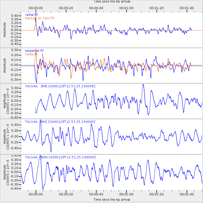
I14A Mackay, ID, USA - Earthquake Result Viewer
*The percent match for this event was below the threshold and hence no stack was calculated.
| Earthquake location: |
Samoa Islands Region |
| Earthquake latitude/longitude: |
-17.0/-172.1 |
| Earthquake time(UTC): |
2009/01/28 (028) 12:39:42 GMT |
| Earthquake Depth: |
10 km |
| Earthquake Magnitude: |
5.6 MB, 5.3 MS, 5.5 MW |
| Earthquake Catalog/Contributor: |
WHDF/NEIC |
|
| Network: |
TA USArray Transportable Network (new EarthScope stations) |
| Station: |
I14A Mackay, ID, USA |
| Lat/Lon: |
43.93 N/113.45 W |
| Elevation: |
1897 m |
|
| Distance: |
80.8 deg |
| Az: |
38.669 deg |
| Baz: |
235.85 deg |
| Ray Param: |
$rayparam |
*The percent match for this event was below the threshold and hence was not used in the summary stack. |
|
| Radial Match: |
43.905357 % |
| Radial Bump: |
382 |
| Transverse Match: |
71.11367 % |
| Transverse Bump: |
377 |
| SOD ConfigId: |
2658 |
| Insert Time: |
2010-03-06 16:46:00.233 +0000 |
| GWidth: |
2.5 |
| Max Bumps: |
400 |
| Tol: |
0.001 |
|
Signal To Noise
| Channel | StoN | STA | LTA |
| TA:I14A: :BHZ:20090128T12:51:25.249006Z | 2.9097712 | 2.471617E-7 | 8.494197E-8 |
| TA:I14A: :BHN:20090128T12:51:25.249006Z | 1.5128651 | 2.6601978E-7 | 1.758384E-7 |
| TA:I14A: :BHE:20090128T12:51:25.249006Z | 0.87616396 | 1.10306175E-7 | 1.2589673E-7 |
| Arrivals |
| Ps | |
| PpPs | |
| PsPs/PpSs | |


