You are here: Home > Network List > TA - USArray Transportable Network (new EarthScope stations) Stations List
> Station I14A Mackay, ID, USA > Earthquake Result Viewer
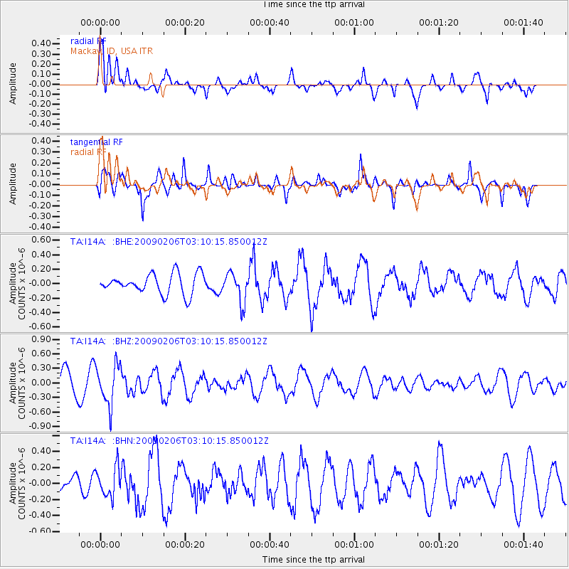
I14A Mackay, ID, USA - Earthquake Result Viewer
*The percent match for this event was below the threshold and hence no stack was calculated.
| Earthquake location: |
Near Coast Of Northern Chile |
| Earthquake latitude/longitude: |
-28.0/-71.1 |
| Earthquake time(UTC): |
2009/02/06 (037) 02:58:35 GMT |
| Earthquake Depth: |
52 km |
| Earthquake Magnitude: |
5.5 MB |
| Earthquake Catalog/Contributor: |
WHDF/NEIC |
|
| Network: |
TA USArray Transportable Network (new EarthScope stations) |
| Station: |
I14A Mackay, ID, USA |
| Lat/Lon: |
43.93 N/113.45 W |
| Elevation: |
1897 m |
|
| Distance: |
81.4 deg |
| Az: |
330.511 deg |
| Baz: |
142.951 deg |
| Ray Param: |
$rayparam |
*The percent match for this event was below the threshold and hence was not used in the summary stack. |
|
| Radial Match: |
55.748543 % |
| Radial Bump: |
400 |
| Transverse Match: |
73.58783 % |
| Transverse Bump: |
400 |
| SOD ConfigId: |
2658 |
| Insert Time: |
2010-03-06 16:46:08.662 +0000 |
| GWidth: |
2.5 |
| Max Bumps: |
400 |
| Tol: |
0.001 |
|
Signal To Noise
| Channel | StoN | STA | LTA |
| TA:I14A: :BHZ:20090206T03:10:15.850012Z | 1.4693587 | 4.1167016E-7 | 2.8016996E-7 |
| TA:I14A: :BHN:20090206T03:10:15.850012Z | 0.961134 | 1.8320972E-7 | 1.9061828E-7 |
| TA:I14A: :BHE:20090206T03:10:15.850012Z | 1.5091147 | 2.100062E-7 | 1.3915854E-7 |
| Arrivals |
| Ps | |
| PpPs | |
| PsPs/PpSs | |


