You are here: Home > Network List > TA - USArray Transportable Network (new EarthScope stations) Stations List
> Station I14A Mackay, ID, USA > Earthquake Result Viewer
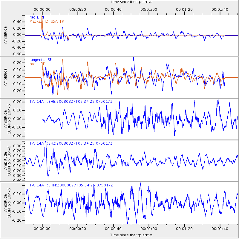
I14A Mackay, ID, USA - Earthquake Result Viewer
*The percent match for this event was below the threshold and hence no stack was calculated.
| Earthquake location: |
Kuril Islands |
| Earthquake latitude/longitude: |
46.7/152.5 |
| Earthquake time(UTC): |
2008/08/27 (240) 05:24:41 GMT |
| Earthquake Depth: |
65 km |
| Earthquake Magnitude: |
5.5 MB, 5.4 MW, 5.3 MW |
| Earthquake Catalog/Contributor: |
WHDF/NEIC |
|
| Network: |
TA USArray Transportable Network (new EarthScope stations) |
| Station: |
I14A Mackay, ID, USA |
| Lat/Lon: |
43.93 N/113.45 W |
| Elevation: |
1897 m |
|
| Distance: |
62.2 deg |
| Az: |
54.569 deg |
| Baz: |
309.122 deg |
| Ray Param: |
$rayparam |
*The percent match for this event was below the threshold and hence was not used in the summary stack. |
|
| Radial Match: |
66.15353 % |
| Radial Bump: |
400 |
| Transverse Match: |
46.904873 % |
| Transverse Bump: |
400 |
| SOD ConfigId: |
2504 |
| Insert Time: |
2010-03-06 16:46:16.604 +0000 |
| GWidth: |
2.5 |
| Max Bumps: |
400 |
| Tol: |
0.001 |
|
Signal To Noise
| Channel | StoN | STA | LTA |
| TA:I14A: :BHZ:20080827T05:34:25.075017Z | 2.9794247 | 2.0184099E-7 | 6.7744956E-8 |
| TA:I14A: :BHN:20080827T05:34:25.075017Z | 1.1935003 | 9.202543E-8 | 7.710549E-8 |
| TA:I14A: :BHE:20080827T05:34:25.075017Z | 1.25042 | 6.595818E-8 | 5.2748824E-8 |
| Arrivals |
| Ps | |
| PpPs | |
| PsPs/PpSs | |


