You are here: Home > Network List > TS - TERRAscope (Southern California Seismic Network) Stations List
> Station BAR Barrett Dam, California, USA > Earthquake Result Viewer
BAR Barrett Dam, California, USA - Earthquake Result Viewer
| Earthquake location: |
Near Coast Of Peru |
| Earthquake latitude/longitude: |
-10.5/-78.7 |
| Earthquake time(UTC): |
1995/09/23 (266) 22:31:58 GMT |
| Earthquake Depth: |
73 km |
| Earthquake Magnitude: |
5.9 MB, 6.5 UNKNOWN, 6.4 MW |
| Earthquake Catalog/Contributor: |
WHDF/NEIC |
|
| Network: |
TS TERRAscope (Southern California Seismic Network) |
| Station: |
BAR Barrett Dam, California, USA |
| Lat/Lon: |
32.68 N/116.67 W |
| Elevation: |
548 m |
|
| Distance: |
56.2 deg |
| Az: |
321.361 deg |
| Baz: |
133.273 deg |
| Ray Param: |
0.06409097 |
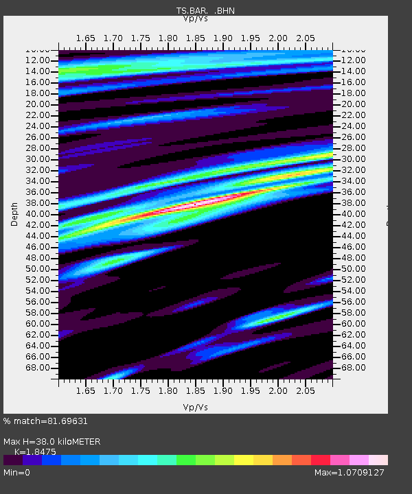
| Estimated Moho Depth: |
38.0 km |
| Estimated Crust Vp/Vs: |
1.85 |
| Assumed Crust Vp: |
6.264 km/s |
| Estimated Crust Vs: |
3.39 km/s |
| Estimated Crust Poisson's Ratio: |
0.29 |
|
| Radial Match: |
81.69631 % |
| Radial Bump: |
400 |
| Transverse Match: |
69.23182 % |
| Transverse Bump: |
400 |
| SOD ConfigId: |
6273 |
| Insert Time: |
2010-02-26 13:58:29.911 +0000 |
| GWidth: |
2.5 |
| Max Bumps: |
400 |
| Tol: |
0.001 |
|
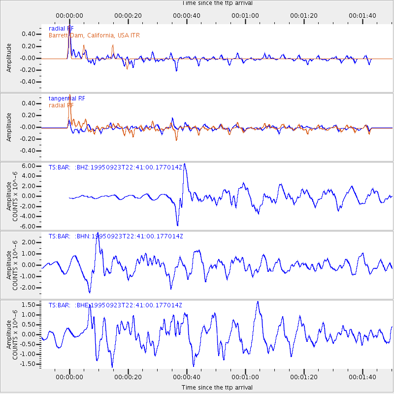
Signal To Noise
| Channel | StoN | STA | LTA |
| TS:BAR: :BHN:19950923T22:41:00.177014Z | 2.6785624 | 5.691324E-7 | 2.124768E-7 |
| TS:BAR: :BHE:19950923T22:41:00.177014Z | 1.3375503 | 1.7241733E-7 | 1.289053E-7 |
| TS:BAR: :BHZ:19950923T22:41:00.177014Z | 1.7795889 | 4.111669E-7 | 2.31046E-7 |
| Arrivals |
| Ps | 5.4 SECOND |
| PpPs | 16 SECOND |
| PsPs/PpSs | 22 SECOND |


