You are here: Home > Network List > TA - USArray Transportable Network (new EarthScope stations) Stations List
> Station I14A Mackay, ID, USA > Earthquake Result Viewer
I14A Mackay, ID, USA - Earthquake Result Viewer
*The percent match for this event was below the threshold and hence no stack was calculated.
| Earthquake location: |
Hokkaido, Japan Region |
| Earthquake latitude/longitude: |
41.6/140.4 |
| Earthquake time(UTC): |
2008/09/22 (266) 07:31:59 GMT |
| Earthquake Depth: |
149 km |
| Earthquake Magnitude: |
5.7 MW, 5.3 MB, 5.6 MW |
| Earthquake Catalog/Contributor: |
WHDF/NEIC |
|
| Network: |
TA USArray Transportable Network (new EarthScope stations) |
| Station: |
I14A Mackay, ID, USA |
| Lat/Lon: |
43.93 N/113.45 W |
| Elevation: |
1897 m |
|
| Distance: |
72.1 deg |
| Az: |
46.833 deg |
| Baz: |
310.768 deg |
| Ray Param: |
$rayparam |
*The percent match for this event was below the threshold and hence was not used in the summary stack. |
|
| Radial Match: |
67.00539 % |
| Radial Bump: |
400 |
| Transverse Match: |
58.214912 % |
| Transverse Bump: |
400 |
| SOD ConfigId: |
2560 |
| Insert Time: |
2010-03-06 16:46:22.553 +0000 |
| GWidth: |
2.5 |
| Max Bumps: |
400 |
| Tol: |
0.001 |
|
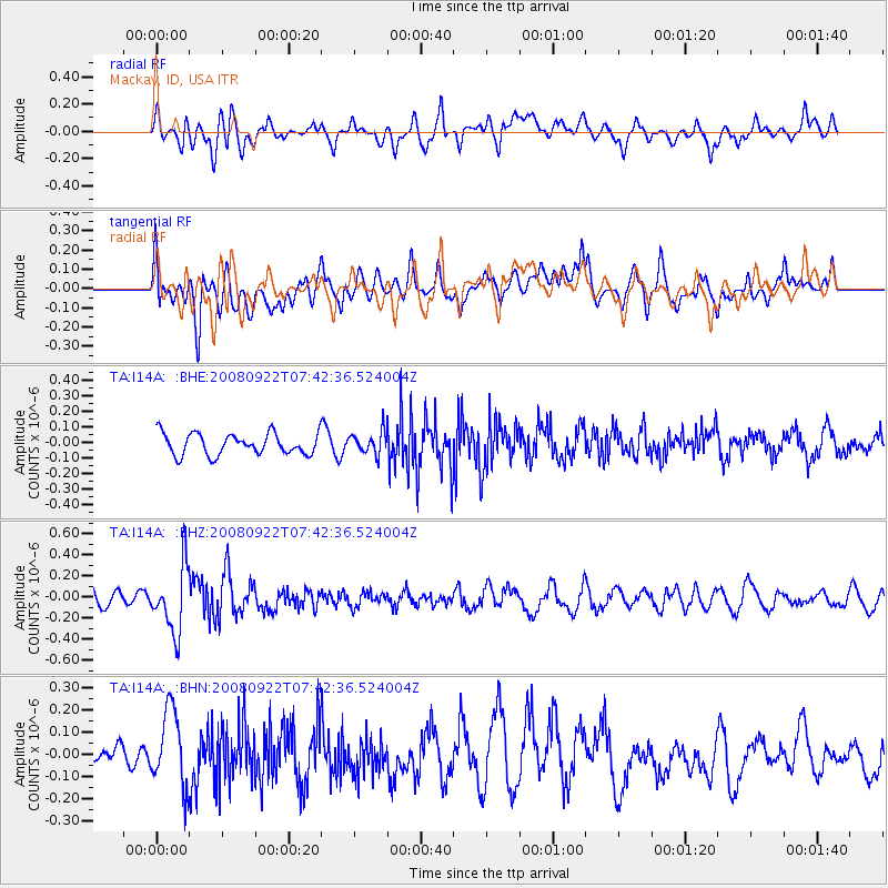
Signal To Noise
| Channel | StoN | STA | LTA |
| TA:I14A: :BHZ:20080922T07:42:36.524004Z | 4.441759 | 3.155198E-7 | 7.1034876E-8 |
| TA:I14A: :BHN:20080922T07:42:36.524004Z | 2.6824956 | 1.82066E-7 | 6.787187E-8 |
| TA:I14A: :BHE:20080922T07:42:36.524004Z | 1.0524882 | 7.16688E-8 | 6.8094636E-8 |
| Arrivals |
| Ps | |
| PpPs | |
| PsPs/PpSs | |


