You are here: Home > Network List > TA - USArray Transportable Network (new EarthScope stations) Stations List
> Station I23K Minto, Yukon-Koyukuk, AK, USA > Earthquake Result Viewer
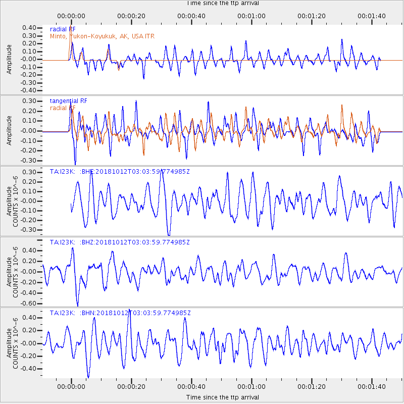
I23K Minto, Yukon-Koyukuk, AK, USA - Earthquake Result Viewer
*The percent match for this event was below the threshold and hence no stack was calculated.
| Earthquake location: |
New Britain Region, P.N.G. |
| Earthquake latitude/longitude: |
-6.3/151.1 |
| Earthquake time(UTC): |
2018/10/12 (285) 02:52:07 GMT |
| Earthquake Depth: |
35 km |
| Earthquake Magnitude: |
5.7 Mww |
| Earthquake Catalog/Contributor: |
NEIC PDE/us |
|
| Network: |
TA USArray Transportable Network (new EarthScope stations) |
| Station: |
I23K Minto, Yukon-Koyukuk, AK, USA |
| Lat/Lon: |
65.15 N/149.36 W |
| Elevation: |
149 m |
|
| Distance: |
83.5 deg |
| Az: |
21.519 deg |
| Baz: |
239.634 deg |
| Ray Param: |
$rayparam |
*The percent match for this event was below the threshold and hence was not used in the summary stack. |
|
| Radial Match: |
52.477966 % |
| Radial Bump: |
304 |
| Transverse Match: |
60.688175 % |
| Transverse Bump: |
400 |
| SOD ConfigId: |
13570011 |
| Insert Time: |
2019-05-01 12:11:53.918 +0000 |
| GWidth: |
2.5 |
| Max Bumps: |
400 |
| Tol: |
0.001 |
|
Signal To Noise
| Channel | StoN | STA | LTA |
| TA:I23K: :BHZ:20181012T03:03:59.774985Z | 3.4961536 | 3.102484E-7 | 8.8739924E-8 |
| TA:I23K: :BHN:20181012T03:03:59.774985Z | 1.4442044 | 1.3769674E-7 | 9.5344355E-8 |
| TA:I23K: :BHE:20181012T03:03:59.774985Z | 1.7682977 | 2.2040598E-7 | 1.2464302E-7 |
| Arrivals |
| Ps | |
| PpPs | |
| PsPs/PpSs | |


