You are here: Home > Network List > TA - USArray Transportable Network (new EarthScope stations) Stations List
> Station H15A Lima, MT, USA > Earthquake Result Viewer
H15A Lima, MT, USA - Earthquake Result Viewer
| Earthquake location: |
Colombia |
| Earthquake latitude/longitude: |
4.8/-75.5 |
| Earthquake time(UTC): |
2008/09/13 (257) 09:32:01 GMT |
| Earthquake Depth: |
133 km |
| Earthquake Magnitude: |
5.9 MB, 5.7 MW, 5.7 MW |
| Earthquake Catalog/Contributor: |
WHDF/NEIC |
|
| Network: |
TA USArray Transportable Network (new EarthScope stations) |
| Station: |
H15A Lima, MT, USA |
| Lat/Lon: |
44.62 N/112.64 W |
| Elevation: |
1957 m |
|
| Distance: |
51.3 deg |
| Az: |
326.462 deg |
| Baz: |
129.562 deg |
| Ray Param: |
0.067064375 |
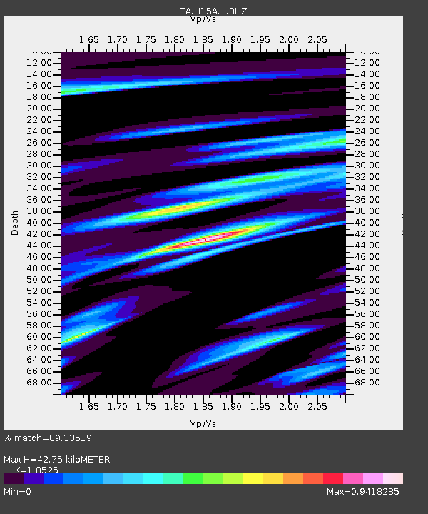
| Estimated Moho Depth: |
42.75 km |
| Estimated Crust Vp/Vs: |
1.85 |
| Assumed Crust Vp: |
6.577 km/s |
| Estimated Crust Vs: |
3.55 km/s |
| Estimated Crust Poisson's Ratio: |
0.29 |
|
| Radial Match: |
89.33519 % |
| Radial Bump: |
400 |
| Transverse Match: |
75.73939 % |
| Transverse Bump: |
400 |
| SOD ConfigId: |
2560 |
| Insert Time: |
2010-03-06 16:46:39.077 +0000 |
| GWidth: |
2.5 |
| Max Bumps: |
400 |
| Tol: |
0.001 |
|

Signal To Noise
| Channel | StoN | STA | LTA |
| TA:H15A: :BHZ:20080913T09:40:21.275004Z | 19.659437 | 1.959817E-6 | 9.968836E-8 |
| TA:H15A: :BHN:20080913T09:40:21.275004Z | 5.398606 | 5.589559E-7 | 1.0353708E-7 |
| TA:H15A: :BHE:20080913T09:40:21.275004Z | 9.205885 | 8.16806E-7 | 8.872651E-8 |
| Arrivals |
| Ps | 5.9 SECOND |
| PpPs | 18 SECOND |
| PsPs/PpSs | 23 SECOND |


