You are here: Home > Network List > TS - TERRAscope (Southern California Seismic Network) Stations List
> Station BAR Barrett Dam, California, USA > Earthquake Result Viewer
BAR Barrett Dam, California, USA - Earthquake Result Viewer
| Earthquake location: |
Ryukyu Islands, Japan |
| Earthquake latitude/longitude: |
27.9/130.3 |
| Earthquake time(UTC): |
1995/10/18 (291) 10:37:26 GMT |
| Earthquake Depth: |
27 km |
| Earthquake Magnitude: |
6.5 MB, 6.8 MS, 6.7 UNKNOWN, 7.1 MW |
| Earthquake Catalog/Contributor: |
WHDF/NEIC |
|
| Network: |
TS TERRAscope (Southern California Seismic Network) |
| Station: |
BAR Barrett Dam, California, USA |
| Lat/Lon: |
32.68 N/116.67 W |
| Elevation: |
548 m |
|
| Distance: |
92.4 deg |
| Az: |
50.988 deg |
| Baz: |
305.383 deg |
| Ray Param: |
0.041463885 |
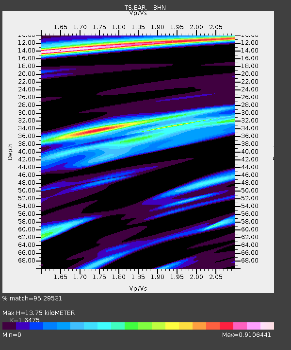
| Estimated Moho Depth: |
13.75 km |
| Estimated Crust Vp/Vs: |
1.65 |
| Assumed Crust Vp: |
6.264 km/s |
| Estimated Crust Vs: |
3.802 km/s |
| Estimated Crust Poisson's Ratio: |
0.21 |
|
| Radial Match: |
95.29531 % |
| Radial Bump: |
276 |
| Transverse Match: |
87.84098 % |
| Transverse Bump: |
400 |
| SOD ConfigId: |
6273 |
| Insert Time: |
2010-02-26 13:58:31.070 +0000 |
| GWidth: |
2.5 |
| Max Bumps: |
400 |
| Tol: |
0.001 |
|
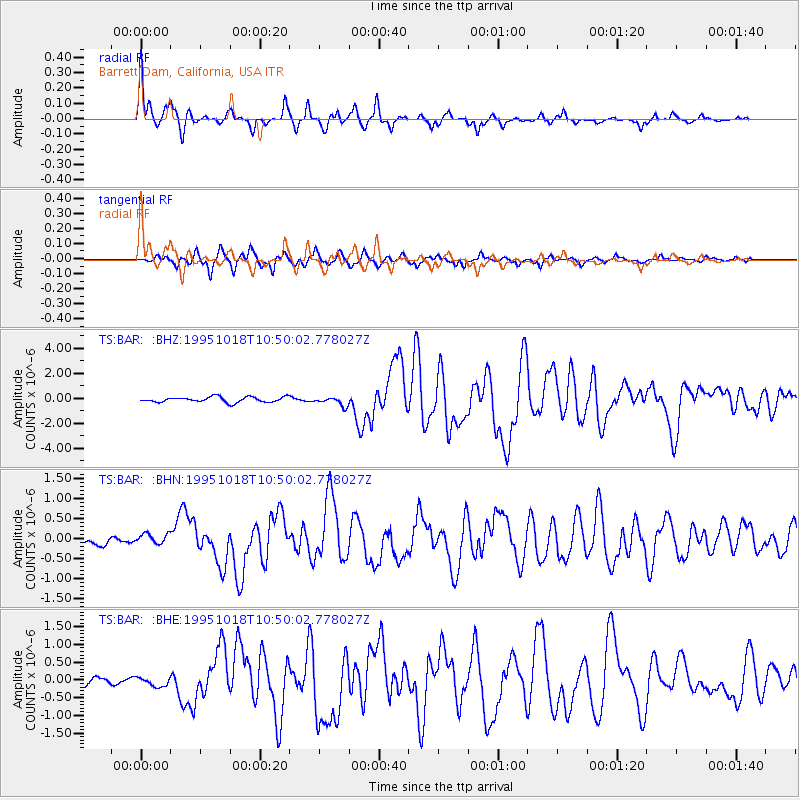
Signal To Noise
| Channel | StoN | STA | LTA |
| TS:BAR: :BHN:19951018T10:50:02.778027Z | 1.3180032 | 1.3534344E-7 | 1.02688254E-7 |
| TS:BAR: :BHE:19951018T10:50:02.778027Z | 1.0634578 | 1.2679976E-7 | 1.1923346E-7 |
| TS:BAR: :BHZ:19951018T10:50:02.778027Z | 1.6671984 | 3.5839955E-7 | 2.1497114E-7 |
| Arrivals |
| Ps | 1.5 SECOND |
| PpPs | 5.7 SECOND |
| PsPs/PpSs | 7.1 SECOND |


