You are here: Home > Network List > TA - USArray Transportable Network (new EarthScope stations) Stations List
> Station H15A Lima, MT, USA > Earthquake Result Viewer
H15A Lima, MT, USA - Earthquake Result Viewer
| Earthquake location: |
South Of Panama |
| Earthquake latitude/longitude: |
5.7/-82.8 |
| Earthquake time(UTC): |
2009/03/12 (071) 23:23:34 GMT |
| Earthquake Depth: |
9.0 km |
| Earthquake Magnitude: |
6.1 MB, 5.9 MS, 6.3 MW, 6.2 MW |
| Earthquake Catalog/Contributor: |
WHDF/NEIC |
|
| Network: |
TA USArray Transportable Network (new EarthScope stations) |
| Station: |
H15A Lima, MT, USA |
| Lat/Lon: |
44.62 N/112.64 W |
| Elevation: |
1957 m |
|
| Distance: |
46.8 deg |
| Az: |
330.765 deg |
| Baz: |
137.114 deg |
| Ray Param: |
0.070448525 |
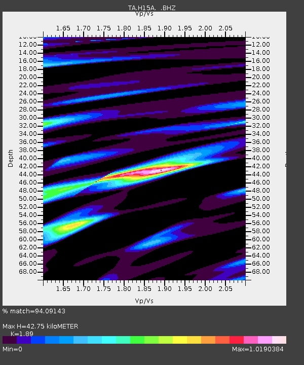
| Estimated Moho Depth: |
42.75 km |
| Estimated Crust Vp/Vs: |
1.89 |
| Assumed Crust Vp: |
6.577 km/s |
| Estimated Crust Vs: |
3.48 km/s |
| Estimated Crust Poisson's Ratio: |
0.31 |
|
| Radial Match: |
94.09143 % |
| Radial Bump: |
400 |
| Transverse Match: |
83.21562 % |
| Transverse Bump: |
400 |
| SOD ConfigId: |
2658 |
| Insert Time: |
2010-03-06 16:47:21.042 +0000 |
| GWidth: |
2.5 |
| Max Bumps: |
400 |
| Tol: |
0.001 |
|

Signal To Noise
| Channel | StoN | STA | LTA |
| TA:H15A: :BHZ:20090312T23:31:33.373986Z | 2.6415396 | 4.1955894E-7 | 1.5883121E-7 |
| TA:H15A: :BHN:20090312T23:31:33.373986Z | 2.3013122 | 3.524234E-7 | 1.531402E-7 |
| TA:H15A: :BHE:20090312T23:31:33.373986Z | 1.068269 | 1.8477193E-7 | 1.7296387E-7 |
| Arrivals |
| Ps | 6.1 SECOND |
| PpPs | 18 SECOND |
| PsPs/PpSs | 24 SECOND |


