LPAZ La Paz , Bolivia - Earthquake Result Viewer
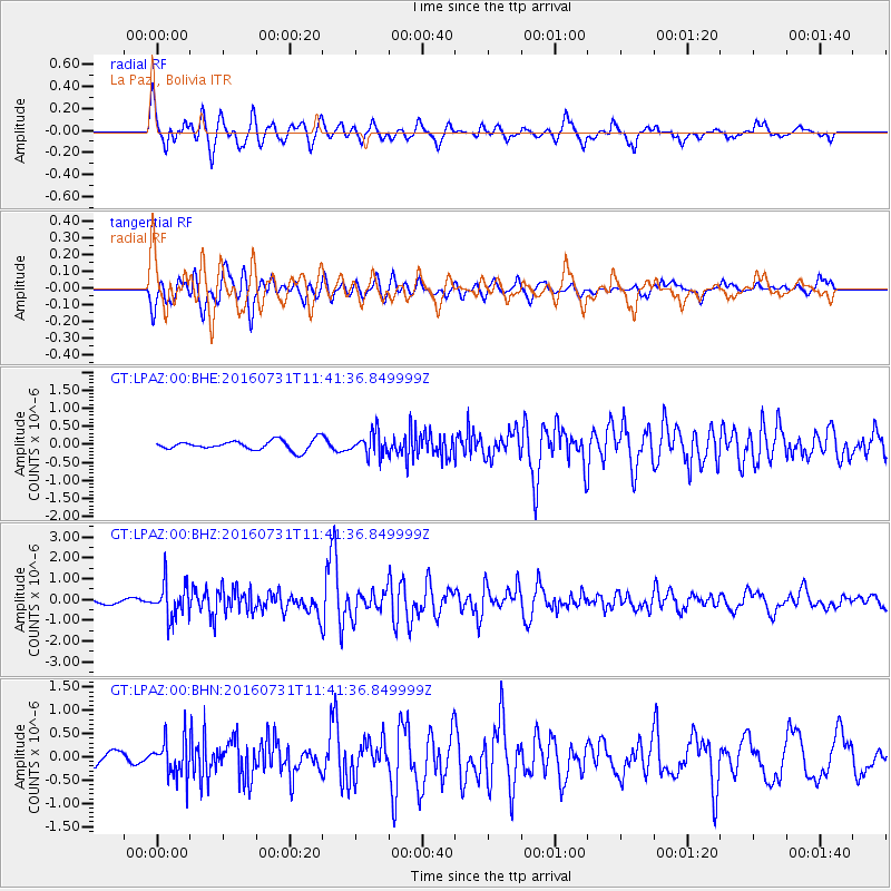
Earthquake location: South Sandwich Islands Region
Earthquake latitude/longitude: -56.3/-27.5
Earthquake time(UTC): 2016/07/31 (213) 11:33:20 GMT
Earthquake Depth: 98 km
Earthquake Magnitude: 5.9 MWW, 5.9 MWC, 5.9 MWB
Earthquake Catalog/Contributor: NEIC PDE/NEIC COMCAT
Network: GT Global Telemetered Seismograph Network (USAF/USGS)
Station: LPAZ La Paz , Bolivia
Lat/Lon: 16.17 S/68.08 W
Elevation: 4817 m
Distance: 50.4 deg
Az: 305.873 deg
Baz: 151.926 deg
Ray Param: 0.06775419
Estimated Moho Depth: 27.25 km
Estimated Crust Vp/Vs: 1.61
Assumed Crust Vp: 6.454 km/s
Estimated Crust Vs: 4.015 km/s
Estimated Crust Poisson's Ratio: 0.18
Radial Match: 84.28353 %
Radial Bump: 400
Transverse Match: 84.63988 %
Transverse Bump: 400
SOD ConfigId: 1634031
Insert Time: 2016-08-14 11:34:21.994 +0000
GWidth: 2.5
Max Bumps: 400
Tol: 0.001

Signal To Noise

ChannelStoNSTALTA
GT:LPAZ:00:BHZ:20160731T11:41:36.849999Z4.78923238.543693E-71.7839379E-7
GT:LPAZ:00:BHN:20160731T11:41:36.849999Z2.00258263.933072E-71.964E-7
GT:LPAZ:00:BHE:20160731T11:41:36.849999Z2.31052423.2555832E-71.4090236E-7
Arrivals
Ps2.7 SECOND
PpPs10 SECOND
PsPs/PpSs13 SECOND