You are here: Home > Network List > TA - USArray Transportable Network (new EarthScope stations) Stations List
> Station H15A Lima, MT, USA > Earthquake Result Viewer
H15A Lima, MT, USA - Earthquake Result Viewer
| Earthquake location: |
Tonga Islands Region |
| Earthquake latitude/longitude: |
-17.3/-171.9 |
| Earthquake time(UTC): |
2008/12/24 (359) 09:11:34 GMT |
| Earthquake Depth: |
9.0 km |
| Earthquake Magnitude: |
5.9 MB, 5.6 MS, 6.0 MW, 6.0 MW |
| Earthquake Catalog/Contributor: |
WHDF/NEIC |
|
| Network: |
TA USArray Transportable Network (new EarthScope stations) |
| Station: |
H15A Lima, MT, USA |
| Lat/Lon: |
44.62 N/112.64 W |
| Elevation: |
1957 m |
|
| Distance: |
81.8 deg |
| Az: |
38.326 deg |
| Baz: |
236.056 deg |
| Ray Param: |
0.04730574 |
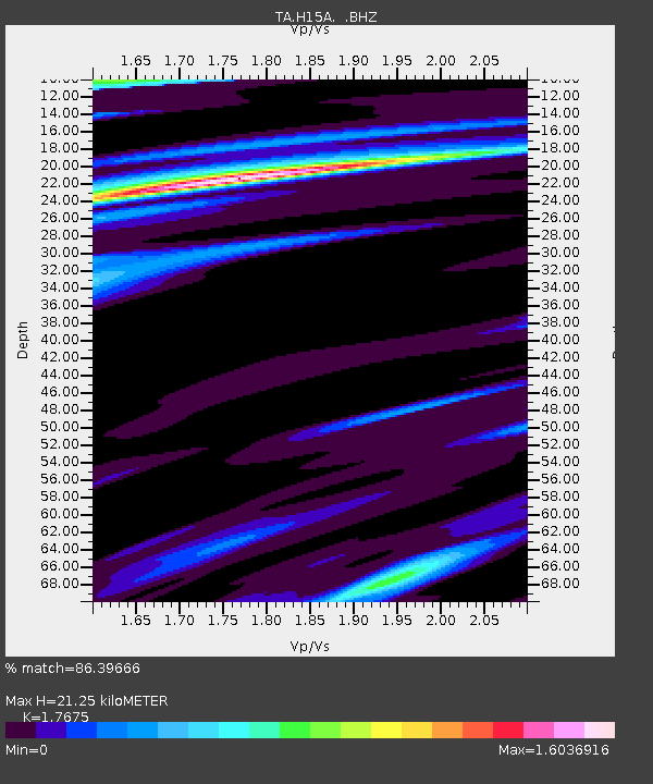
| Estimated Moho Depth: |
21.25 km |
| Estimated Crust Vp/Vs: |
1.77 |
| Assumed Crust Vp: |
6.577 km/s |
| Estimated Crust Vs: |
3.721 km/s |
| Estimated Crust Poisson's Ratio: |
0.26 |
|
| Radial Match: |
86.39666 % |
| Radial Bump: |
400 |
| Transverse Match: |
76.703896 % |
| Transverse Bump: |
400 |
| SOD ConfigId: |
2658 |
| Insert Time: |
2010-03-06 16:47:25.507 +0000 |
| GWidth: |
2.5 |
| Max Bumps: |
400 |
| Tol: |
0.001 |
|

Signal To Noise
| Channel | StoN | STA | LTA |
| TA:H15A: :BHZ:20081224T09:23:22.250022Z | 4.5855203 | 1.0605817E-6 | 2.3128928E-7 |
| TA:H15A: :BHN:20081224T09:23:22.250022Z | 2.9117663 | 7.351407E-7 | 2.5247243E-7 |
| TA:H15A: :BHE:20081224T09:23:22.250022Z | 1.0359913 | 2.5049448E-7 | 2.4179207E-7 |
| Arrivals |
| Ps | 2.6 SECOND |
| PpPs | 8.7 SECOND |
| PsPs/PpSs | 11 SECOND |


