You are here: Home > Network List > TA - USArray Transportable Network (new EarthScope stations) Stations List
> Station H15A Lima, MT, USA > Earthquake Result Viewer
H15A Lima, MT, USA - Earthquake Result Viewer
| Earthquake location: |
South Of Mariana Islands |
| Earthquake latitude/longitude: |
12.5/143.2 |
| Earthquake time(UTC): |
2008/05/09 (130) 21:51:29 GMT |
| Earthquake Depth: |
76 km |
| Earthquake Magnitude: |
6.1 MB, 6.7 MW, 6.7 MW |
| Earthquake Catalog/Contributor: |
WHDF/NEIC |
|
| Network: |
TA USArray Transportable Network (new EarthScope stations) |
| Station: |
H15A Lima, MT, USA |
| Lat/Lon: |
44.62 N/112.64 W |
| Elevation: |
1957 m |
|
| Distance: |
91.1 deg |
| Az: |
43.833 deg |
| Baz: |
288.738 deg |
| Ray Param: |
0.041608777 |
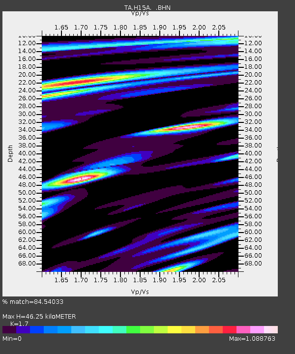
| Estimated Moho Depth: |
46.25 km |
| Estimated Crust Vp/Vs: |
1.70 |
| Assumed Crust Vp: |
6.577 km/s |
| Estimated Crust Vs: |
3.869 km/s |
| Estimated Crust Poisson's Ratio: |
0.24 |
|
| Radial Match: |
84.54033 % |
| Radial Bump: |
400 |
| Transverse Match: |
71.26859 % |
| Transverse Bump: |
400 |
| SOD ConfigId: |
2504 |
| Insert Time: |
2010-03-06 16:47:46.371 +0000 |
| GWidth: |
2.5 |
| Max Bumps: |
400 |
| Tol: |
0.001 |
|

Signal To Noise
| Channel | StoN | STA | LTA |
| TA:H15A: :BHN:20080509T22:03:54.899006Z | 12.0066595 | 4.839858E-7 | 4.0309782E-8 |
| TA:H15A: :BHE:20080509T22:03:54.899006Z | 1.6118227 | 1.18277846E-7 | 7.338142E-8 |
| TA:H15A: :BHZ:20080509T22:03:54.899006Z | 2.1999269 | 1.3184739E-7 | 5.993262E-8 |
| Arrivals |
| Ps | 5.0 SECOND |
| PpPs | 19 SECOND |
| PsPs/PpSs | 24 SECOND |


