You are here: Home > Network List > TS - TERRAscope (Southern California Seismic Network) Stations List
> Station BAR Barrett Dam, California, USA > Earthquake Result Viewer
BAR Barrett Dam, California, USA - Earthquake Result Viewer
| Earthquake location: |
Kermadec Islands Region |
| Earthquake latitude/longitude: |
-31.2/180.0 |
| Earthquake time(UTC): |
1996/11/05 (310) 09:41:34 GMT |
| Earthquake Depth: |
369 km |
| Earthquake Magnitude: |
5.9 MB, 6.8 UNKNOWN, 6.7 MW |
| Earthquake Catalog/Contributor: |
WHDF/NEIC |
|
| Network: |
TS TERRAscope (Southern California Seismic Network) |
| Station: |
BAR Barrett Dam, California, USA |
| Lat/Lon: |
32.68 N/116.67 W |
| Elevation: |
548 m |
|
| Distance: |
87.3 deg |
| Az: |
48.98 deg |
| Baz: |
230.079 deg |
| Ray Param: |
0.042506967 |
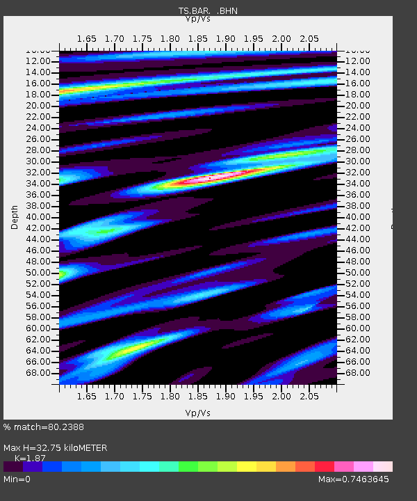
| Estimated Moho Depth: |
32.75 km |
| Estimated Crust Vp/Vs: |
1.87 |
| Assumed Crust Vp: |
6.264 km/s |
| Estimated Crust Vs: |
3.35 km/s |
| Estimated Crust Poisson's Ratio: |
0.30 |
|
| Radial Match: |
80.2388 % |
| Radial Bump: |
400 |
| Transverse Match: |
71.39245 % |
| Transverse Bump: |
400 |
| SOD ConfigId: |
6273 |
| Insert Time: |
2010-02-26 13:58:33.117 +0000 |
| GWidth: |
2.5 |
| Max Bumps: |
400 |
| Tol: |
0.001 |
|
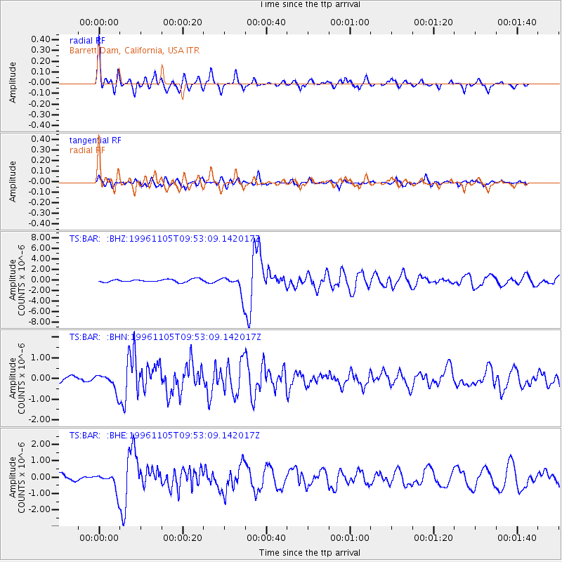
Signal To Noise
| Channel | StoN | STA | LTA |
| TS:BAR: :BHN:19961105T09:53:09.142017Z | 2.5723014 | 4.438796E-7 | 1.7256126E-7 |
| TS:BAR: :BHE:19961105T09:53:09.142017Z | 2.8237872 | 5.9028895E-7 | 2.0904157E-7 |
| TS:BAR: :BHZ:19961105T09:53:09.142017Z | 7.806879 | 2.0263067E-6 | 2.59554E-7 |
| Arrivals |
| Ps | 4.6 SECOND |
| PpPs | 15 SECOND |
| PsPs/PpSs | 19 SECOND |


