You are here: Home > Network List > TA - USArray Transportable Network (new EarthScope stations) Stations List
> Station G21K Allakaket, AK, USA > Earthquake Result Viewer
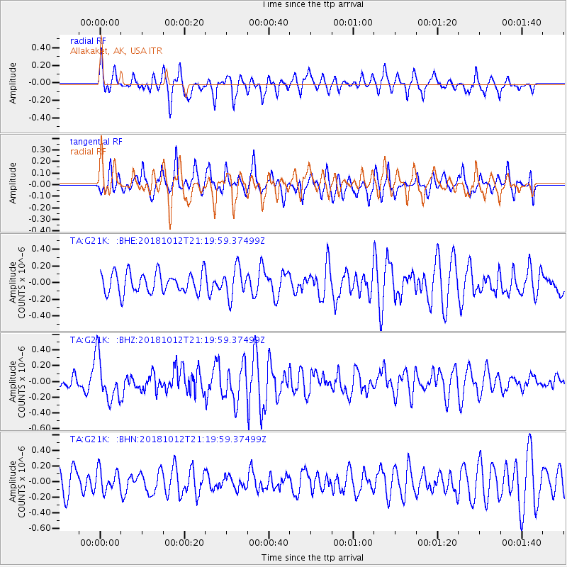
G21K Allakaket, AK, USA - Earthquake Result Viewer
*The percent match for this event was below the threshold and hence no stack was calculated.
| Earthquake location: |
Guatemala |
| Earthquake latitude/longitude: |
14.2/-91.2 |
| Earthquake time(UTC): |
2018/10/12 (285) 21:09:49 GMT |
| Earthquake Depth: |
67 km |
| Earthquake Magnitude: |
5.6 Mww |
| Earthquake Catalog/Contributor: |
NEIC PDE/us |
|
| Network: |
TA USArray Transportable Network (new EarthScope stations) |
| Station: |
G21K Allakaket, AK, USA |
| Lat/Lon: |
66.52 N/153.51 W |
| Elevation: |
446 m |
|
| Distance: |
66.2 deg |
| Az: |
337.182 deg |
| Baz: |
110.188 deg |
| Ray Param: |
$rayparam |
*The percent match for this event was below the threshold and hence was not used in the summary stack. |
|
| Radial Match: |
67.30644 % |
| Radial Bump: |
400 |
| Transverse Match: |
60.957752 % |
| Transverse Bump: |
400 |
| SOD ConfigId: |
13570011 |
| Insert Time: |
2019-05-01 12:19:27.609 +0000 |
| GWidth: |
2.5 |
| Max Bumps: |
400 |
| Tol: |
0.001 |
|
Signal To Noise
| Channel | StoN | STA | LTA |
| TA:G21K: :BHZ:20181012T21:19:59.37499Z | 3.3184617 | 2.7571812E-7 | 8.308613E-8 |
| TA:G21K: :BHN:20181012T21:19:59.37499Z | 0.7829872 | 1.3710002E-7 | 1.7509866E-7 |
| TA:G21K: :BHE:20181012T21:19:59.37499Z | 1.4905246 | 1.7971864E-7 | 1.2057409E-7 |
| Arrivals |
| Ps | |
| PpPs | |
| PsPs/PpSs | |


