You are here: Home > Network List > TA - USArray Transportable Network (new EarthScope stations) Stations List
> Station H15A Lima, MT, USA > Earthquake Result Viewer
H15A Lima, MT, USA - Earthquake Result Viewer
| Earthquake location: |
Sea Of Okhotsk |
| Earthquake latitude/longitude: |
53.9/152.9 |
| Earthquake time(UTC): |
2008/07/05 (187) 02:12:04 GMT |
| Earthquake Depth: |
633 km |
| Earthquake Magnitude: |
6.8 MB, 7.7 MW, 7.7 MW |
| Earthquake Catalog/Contributor: |
WHDF/NEIC |
|
| Network: |
TA USArray Transportable Network (new EarthScope stations) |
| Station: |
H15A Lima, MT, USA |
| Lat/Lon: |
44.62 N/112.64 W |
| Elevation: |
1957 m |
|
| Distance: |
57.9 deg |
| Az: |
57.176 deg |
| Baz: |
315.843 deg |
| Ray Param: |
0.060504284 |
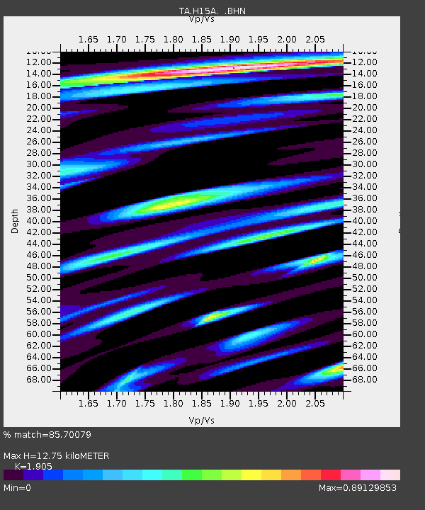
| Estimated Moho Depth: |
12.75 km |
| Estimated Crust Vp/Vs: |
1.90 |
| Assumed Crust Vp: |
6.577 km/s |
| Estimated Crust Vs: |
3.452 km/s |
| Estimated Crust Poisson's Ratio: |
0.31 |
|
| Radial Match: |
85.70079 % |
| Radial Bump: |
400 |
| Transverse Match: |
84.32358 % |
| Transverse Bump: |
400 |
| SOD ConfigId: |
2504 |
| Insert Time: |
2010-03-06 16:47:57.036 +0000 |
| GWidth: |
2.5 |
| Max Bumps: |
400 |
| Tol: |
0.001 |
|

Signal To Noise
| Channel | StoN | STA | LTA |
| TA:H15A: :BHN:20080705T02:20:27.400013Z | 33.315792 | 4.862279E-6 | 1.4594517E-7 |
| TA:H15A: :BHE:20080705T02:20:27.400013Z | 13.354535 | 1.7089217E-6 | 1.2796565E-7 |
| TA:H15A: :BHZ:20080705T02:20:27.400013Z | 18.344288 | 1.5619677E-6 | 8.514736E-8 |
| Arrivals |
| Ps | 1.8 SECOND |
| PpPs | 5.4 SECOND |
| PsPs/PpSs | 7.2 SECOND |


