You are here: Home > Network List > TS - TERRAscope (Southern California Seismic Network) Stations List
> Station BAR Barrett Dam, California, USA > Earthquake Result Viewer
BAR Barrett Dam, California, USA - Earthquake Result Viewer
| Earthquake location: |
Near N. Coast Of Eastern Siberia |
| Earthquake latitude/longitude: |
67.0/-173.2 |
| Earthquake time(UTC): |
1996/10/24 (298) 19:31:53 GMT |
| Earthquake Depth: |
20 km |
| Earthquake Magnitude: |
6.0 MB, 5.9 MS, 6.1 UNKNOWN, 5.8 ME |
| Earthquake Catalog/Contributor: |
WHDF/NEIC |
|
| Network: |
TS TERRAscope (Southern California Seismic Network) |
| Station: |
BAR Barrett Dam, California, USA |
| Lat/Lon: |
32.68 N/116.67 W |
| Elevation: |
548 m |
|
| Distance: |
47.4 deg |
| Az: |
107.067 deg |
| Baz: |
333.532 deg |
| Ray Param: |
0.06998642 |
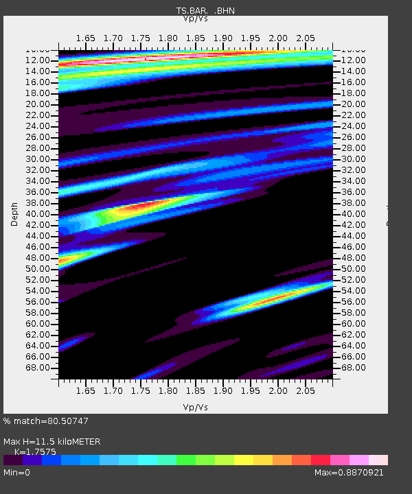
| Estimated Moho Depth: |
11.5 km |
| Estimated Crust Vp/Vs: |
1.76 |
| Assumed Crust Vp: |
6.264 km/s |
| Estimated Crust Vs: |
3.564 km/s |
| Estimated Crust Poisson's Ratio: |
0.26 |
|
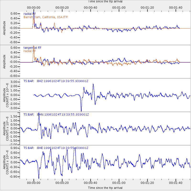
| Radial Match: |
80.50747 % |
| Radial Bump: |
400 |
| Transverse Match: |
59.089314 % |
| Transverse Bump: |
400 |
| SOD ConfigId: |
6273 |
| Insert Time: |
2010-02-26 13:58:34.284 +0000 |
| GWidth: |
2.5 |
| Max Bumps: |
400 |
| Tol: |
0.001 |
|
Signal To Noise
| Channel | StoN | STA | LTA |
| TS:BAR: :BHN:19961024T19:39:55.939001Z | 4.0833673 | 6.6306274E-7 | 1.6238135E-7 |
| TS:BAR: :BHE:19961024T19:39:55.939001Z | 1.4262712 | 3.2553254E-7 | 2.2824028E-7 |
| TS:BAR: :BHZ:19961024T19:39:55.939001Z | 5.098647 | 1.1128977E-6 | 2.1827316E-7 |
| Arrivals |
| Ps | 1.5 SECOND |
| PpPs | 4.8 SECOND |
| PsPs/PpSs | 6.2 SECOND |


