You are here: Home > Network List > CI - Caltech Regional Seismic Network Stations List
> Station MPM Manuel Prospect Mine, California, USA > Earthquake Result Viewer
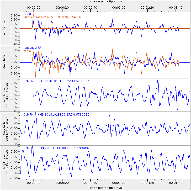
MPM Manuel Prospect Mine, California, USA - Earthquake Result Viewer
*The percent match for this event was below the threshold and hence no stack was calculated.
| Earthquake location: |
Vanuatu Islands |
| Earthquake latitude/longitude: |
-13.7/167.2 |
| Earthquake time(UTC): |
2018/10/13 (286) 00:13:46 GMT |
| Earthquake Depth: |
199 km |
| Earthquake Magnitude: |
5.7 Mww |
| Earthquake Catalog/Contributor: |
NEIC PDE/us |
|
| Network: |
CI Caltech Regional Seismic Network |
| Station: |
MPM Manuel Prospect Mine, California, USA |
| Lat/Lon: |
36.06 N/117.49 W |
| Elevation: |
185 m |
|
| Distance: |
86.4 deg |
| Az: |
51.746 deg |
| Baz: |
250.389 deg |
| Ray Param: |
$rayparam |
*The percent match for this event was below the threshold and hence was not used in the summary stack. |
|
| Radial Match: |
56.85666 % |
| Radial Bump: |
400 |
| Transverse Match: |
42.53255 % |
| Transverse Bump: |
400 |
| SOD ConfigId: |
13570011 |
| Insert Time: |
2019-05-01 12:24:31.024 +0000 |
| GWidth: |
2.5 |
| Max Bumps: |
400 |
| Tol: |
0.001 |
|
Signal To Noise
| Channel | StoN | STA | LTA |
| CI:MPM: :HHZ:20181013T00:25:34.678008Z | 3.2019436 | 3.4084414E-7 | 1.0644914E-7 |
| CI:MPM: :HHN:20181013T00:25:34.678008Z | 1.0630871 | 1.465347E-7 | 1.3783884E-7 |
| CI:MPM: :HHE:20181013T00:25:34.678008Z | 1.4289763 | 1.6786773E-7 | 1.1747411E-7 |
| Arrivals |
| Ps | |
| PpPs | |
| PsPs/PpSs | |


