You are here: Home > Network List > TA - USArray Transportable Network (new EarthScope stations) Stations List
> Station H15A Lima, MT, USA > Earthquake Result Viewer
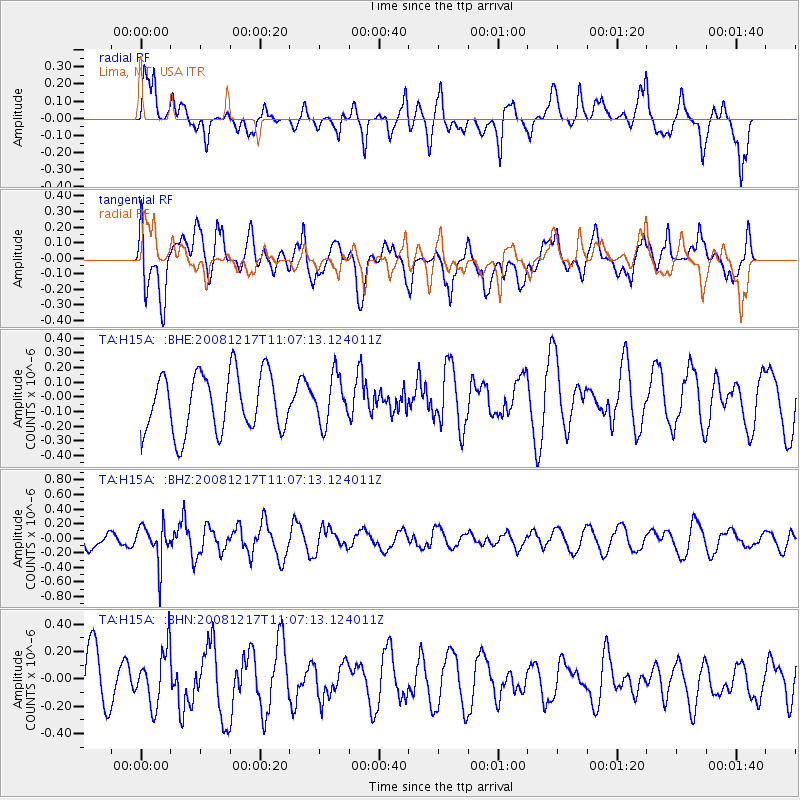
H15A Lima, MT, USA - Earthquake Result Viewer
*The percent match for this event was below the threshold and hence no stack was calculated.
| Earthquake location: |
Fiji Islands Region |
| Earthquake latitude/longitude: |
-17.7/-178.4 |
| Earthquake time(UTC): |
2008/12/17 (352) 10:55:59 GMT |
| Earthquake Depth: |
530 km |
| Earthquake Magnitude: |
5.8 MW, 5.2 MB, 5.8 MW |
| Earthquake Catalog/Contributor: |
WHDF/NEIC |
|
| Network: |
TA USArray Transportable Network (new EarthScope stations) |
| Station: |
H15A Lima, MT, USA |
| Lat/Lon: |
44.62 N/112.64 W |
| Elevation: |
1957 m |
|
| Distance: |
86.1 deg |
| Az: |
40.733 deg |
| Baz: |
240.548 deg |
| Ray Param: |
$rayparam |
*The percent match for this event was below the threshold and hence was not used in the summary stack. |
|
| Radial Match: |
58.01701 % |
| Radial Bump: |
400 |
| Transverse Match: |
60.020863 % |
| Transverse Bump: |
400 |
| SOD ConfigId: |
2658 |
| Insert Time: |
2010-03-06 16:49:05.828 +0000 |
| GWidth: |
2.5 |
| Max Bumps: |
400 |
| Tol: |
0.001 |
|
Signal To Noise
| Channel | StoN | STA | LTA |
| TA:H15A: :BHZ:20081217T11:07:13.124011Z | 2.6261444 | 2.5970792E-7 | 9.889324E-8 |
| TA:H15A: :BHN:20081217T11:07:13.124011Z | 1.288203 | 1.9794302E-7 | 1.5365825E-7 |
| TA:H15A: :BHE:20081217T11:07:13.124011Z | 0.81410784 | 1.6178004E-7 | 1.9872064E-7 |
| Arrivals |
| Ps | |
| PpPs | |
| PsPs/PpSs | |


