BAR Barrett Dam, California, USA - Earthquake Result Viewer
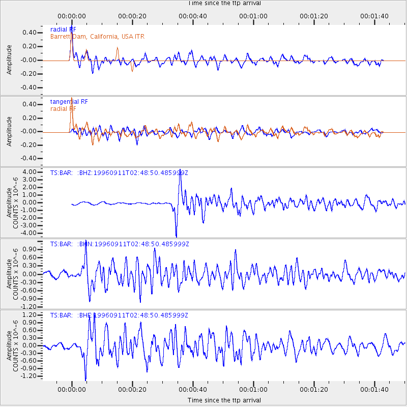
Earthquake location: Near East Coast Of Honshu, Japan
Earthquake latitude/longitude: 35.5/140.9
Earthquake time(UTC): 1996/09/11 (255) 02:37:14 GMT
Earthquake Depth: 55 km
Earthquake Magnitude: 6.1 MB, 5.7 MS, 6.2 UNKNOWN, 6.1 MW
Earthquake Catalog/Contributor: WHDF/NEIC
Network: TS TERRAscope (Southern California Seismic Network)
Station: BAR Barrett Dam, California, USA
Lat/Lon: 32.68 N/116.67 W
Elevation: 548 m
Distance: 80.6 deg
Az: 56.61 deg
Baz: 306.152 deg
Ray Param: 0.048070535
Estimated Moho Depth: 11.75 km
Estimated Crust Vp/Vs: 1.90
Assumed Crust Vp: 6.264 km/s
Estimated Crust Vs: 3.292 km/s
Estimated Crust Poisson's Ratio: 0.31
Radial Match: 89.970505 %
Radial Bump: 400
Transverse Match: 86.88236 %
Transverse Bump: 400
SOD ConfigId: 6273
Insert Time: 2010-02-26 13:58:36.027 +0000
GWidth: 2.5
Max Bumps: 400
Tol: 0.001

Signal To Noise

ChannelStoNSTALTA
TS:BAR: :BHN:19960911T02:48:50.485999Z3.59241253.749237E-71.0436544E-7
TS:BAR: :BHE:19960911T02:48:50.485999Z6.16259864.1315957E-76.7043075E-8
TS:BAR: :BHZ:19960911T02:48:50.485999Z10.7187091.3257039E-61.2368132E-7
Arrivals
Ps1.7 SECOND
PpPs5.3 SECOND
PsPs/PpSs7.0 SECOND