You are here: Home > Network List > TA - USArray Transportable Network (new EarthScope stations) Stations List
> Station F20K Avaraart Lake, AK, USA > Earthquake Result Viewer
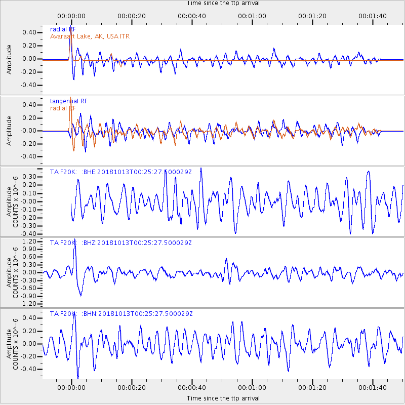
F20K Avaraart Lake, AK, USA - Earthquake Result Viewer
*The percent match for this event was below the threshold and hence no stack was calculated.
| Earthquake location: |
Vanuatu Islands |
| Earthquake latitude/longitude: |
-13.7/167.2 |
| Earthquake time(UTC): |
2018/10/13 (286) 00:13:46 GMT |
| Earthquake Depth: |
199 km |
| Earthquake Magnitude: |
5.7 Mww |
| Earthquake Catalog/Contributor: |
NEIC PDE/us |
|
| Network: |
TA USArray Transportable Network (new EarthScope stations) |
| Station: |
F20K Avaraart Lake, AK, USA |
| Lat/Lon: |
67.05 N/155.73 W |
| Elevation: |
136 m |
|
| Distance: |
84.9 deg |
| Az: |
13.725 deg |
| Baz: |
216.019 deg |
| Ray Param: |
$rayparam |
*The percent match for this event was below the threshold and hence was not used in the summary stack. |
|
| Radial Match: |
59.09049 % |
| Radial Bump: |
400 |
| Transverse Match: |
70.610825 % |
| Transverse Bump: |
400 |
| SOD ConfigId: |
13570011 |
| Insert Time: |
2019-05-01 12:28:13.570 +0000 |
| GWidth: |
2.5 |
| Max Bumps: |
400 |
| Tol: |
0.001 |
|
Signal To Noise
| Channel | StoN | STA | LTA |
| TA:F20K: :BHZ:20181013T00:25:27.500029Z | 6.2442565 | 5.703401E-7 | 9.133835E-8 |
| TA:F20K: :BHN:20181013T00:25:27.500029Z | 2.0343258 | 2.6536839E-7 | 1.3044536E-7 |
| TA:F20K: :BHE:20181013T00:25:27.500029Z | 1.4911952 | 1.9490942E-7 | 1.3070685E-7 |
| Arrivals |
| Ps | |
| PpPs | |
| PsPs/PpSs | |


