You are here: Home > Network List > TA - USArray Transportable Network (new EarthScope stations) Stations List
> Station F26K Sheenjek River, AK, USA > Earthquake Result Viewer
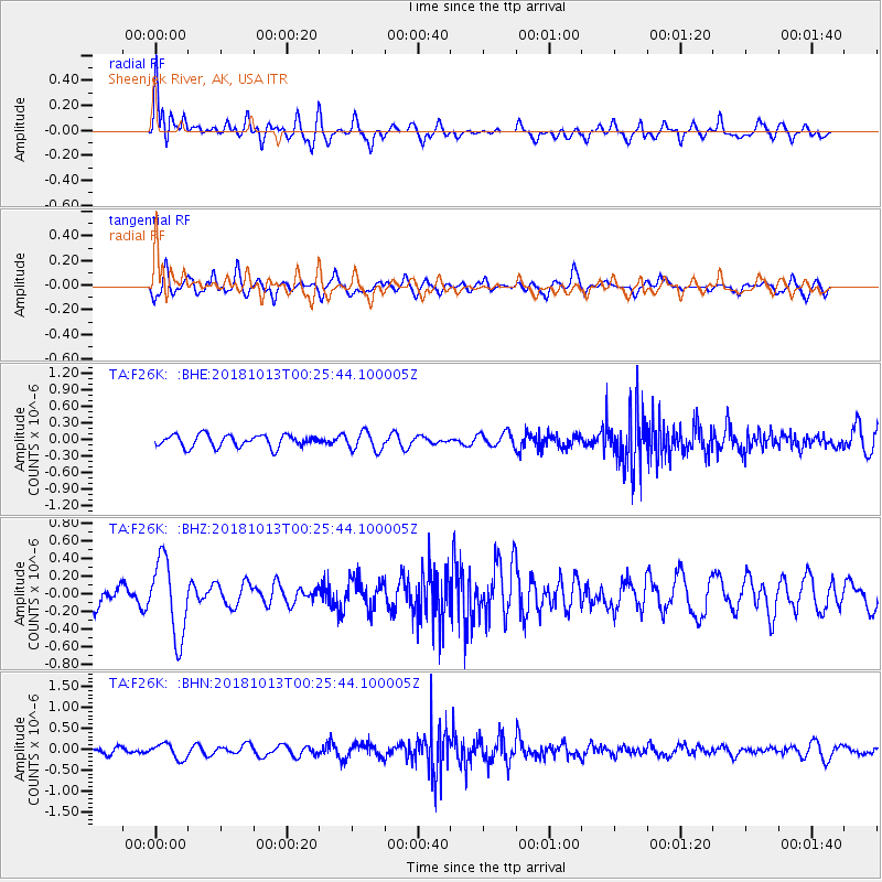
F26K Sheenjek River, AK, USA - Earthquake Result Viewer
*The percent match for this event was below the threshold and hence no stack was calculated.
| Earthquake location: |
Vanuatu Islands |
| Earthquake latitude/longitude: |
-13.7/167.2 |
| Earthquake time(UTC): |
2018/10/13 (286) 00:13:46 GMT |
| Earthquake Depth: |
199 km |
| Earthquake Magnitude: |
5.7 Mww |
| Earthquake Catalog/Contributor: |
NEIC PDE/us |
|
| Network: |
TA USArray Transportable Network (new EarthScope stations) |
| Station: |
F26K Sheenjek River, AK, USA |
| Lat/Lon: |
67.69 N/144.15 W |
| Elevation: |
683 m |
|
| Distance: |
88.4 deg |
| Az: |
16.656 deg |
| Baz: |
226.872 deg |
| Ray Param: |
$rayparam |
*The percent match for this event was below the threshold and hence was not used in the summary stack. |
|
| Radial Match: |
60.547436 % |
| Radial Bump: |
400 |
| Transverse Match: |
59.22805 % |
| Transverse Bump: |
400 |
| SOD ConfigId: |
13570011 |
| Insert Time: |
2019-05-01 12:28:20.278 +0000 |
| GWidth: |
2.5 |
| Max Bumps: |
400 |
| Tol: |
0.001 |
|
Signal To Noise
| Channel | StoN | STA | LTA |
| TA:F26K: :BHZ:20181013T00:25:44.100005Z | 2.980724 | 4.3224355E-7 | 1.4501293E-7 |
| TA:F26K: :BHN:20181013T00:25:44.100005Z | 1.9708872 | 1.8069144E-7 | 9.1680256E-8 |
| TA:F26K: :BHE:20181013T00:25:44.100005Z | 1.533979 | 1.6867915E-7 | 1.0996184E-7 |
| Arrivals |
| Ps | |
| PpPs | |
| PsPs/PpSs | |


