You are here: Home > Network List > TA - USArray Transportable Network (new EarthScope stations) Stations List
> Station R32K Eaglecrest, AK, USA > Earthquake Result Viewer
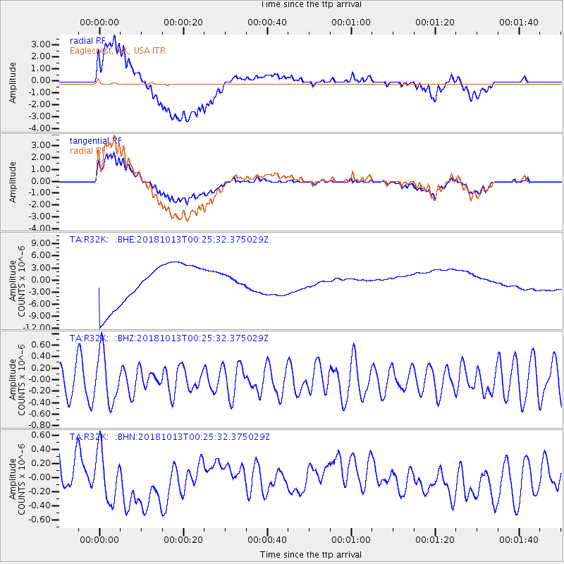
R32K Eaglecrest, AK, USA - Earthquake Result Viewer
*The percent match for this event was below the threshold and hence no stack was calculated.
| Earthquake location: |
Vanuatu Islands |
| Earthquake latitude/longitude: |
-13.7/167.2 |
| Earthquake time(UTC): |
2018/10/13 (286) 00:13:46 GMT |
| Earthquake Depth: |
199 km |
| Earthquake Magnitude: |
5.7 Mww |
| Earthquake Catalog/Contributor: |
NEIC PDE/us |
|
| Network: |
TA USArray Transportable Network (new EarthScope stations) |
| Station: |
R32K Eaglecrest, AK, USA |
| Lat/Lon: |
58.27 N/134.52 W |
| Elevation: |
386 m |
|
| Distance: |
85.9 deg |
| Az: |
26.778 deg |
| Baz: |
235.972 deg |
| Ray Param: |
$rayparam |
*The percent match for this event was below the threshold and hence was not used in the summary stack. |
|
| Radial Match: |
22.029377 % |
| Radial Bump: |
400 |
| Transverse Match: |
20.70923 % |
| Transverse Bump: |
400 |
| SOD ConfigId: |
13570011 |
| Insert Time: |
2019-05-01 12:29:12.896 +0000 |
| GWidth: |
2.5 |
| Max Bumps: |
400 |
| Tol: |
0.001 |
|
Signal To Noise
| Channel | StoN | STA | LTA |
| TA:R32K: :BHZ:20181013T00:25:32.375029Z | 2.3072066 | 4.372881E-7 | 1.895314E-7 |
| TA:R32K: :BHN:20181013T00:25:32.375029Z | 1.7545232 | 3.609672E-7 | 2.057352E-7 |
| TA:R32K: :BHE:20181013T00:25:32.375029Z | 0.23579702 | 1.1991009E-6 | 5.0853096E-6 |
| Arrivals |
| Ps | |
| PpPs | |
| PsPs/PpSs | |


