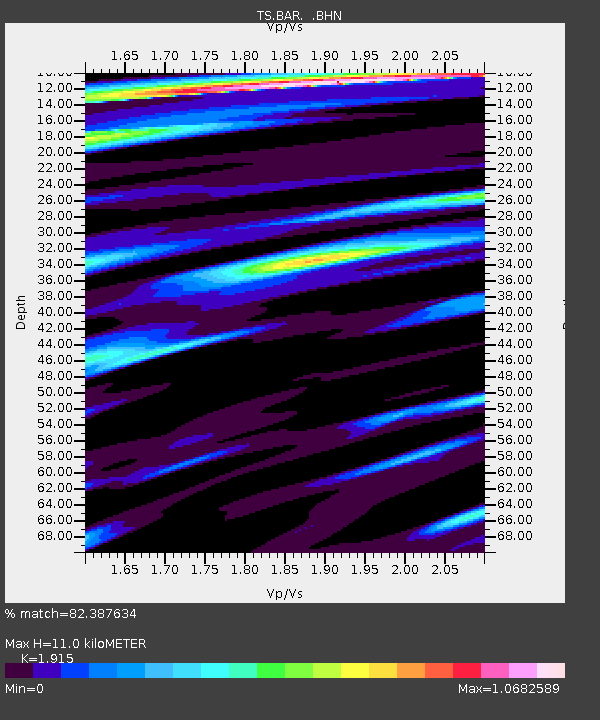
BAR Barrett Dam, California, USA - Earthquake Result Viewer
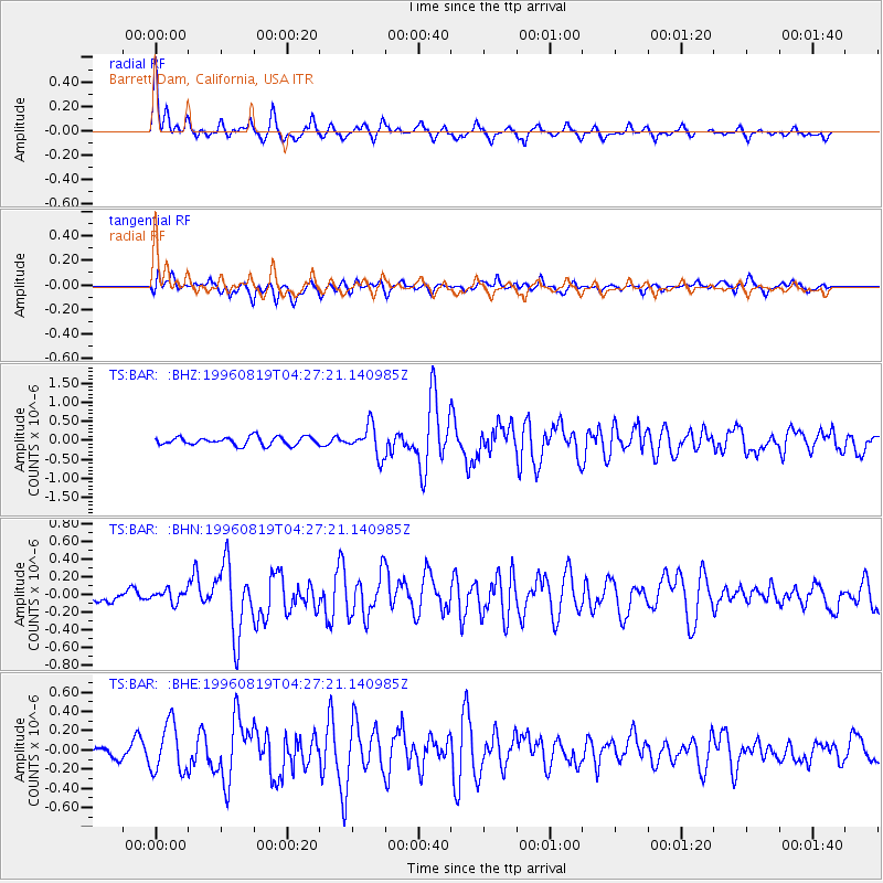
Earthquake location: Andreanof Islands, Aleutian Is.
Earthquake latitude/longitude: 51.5/-178.4
Earthquake time(UTC): 1996/08/19 (232) 04:19:16 GMT
Earthquake Depth: 33 km
Earthquake Magnitude: 5.7 MB, 5.6 MS, 6.0 UNKNOWN, 5.7 ML
Earthquake Catalog/Contributor: WHDF/NEIC
Network: TS TERRAscope (Southern California Seismic Network)
Station: BAR Barrett Dam, California, USA
Lat/Lon: 32.68 N/116.67 W
Elevation: 548 m
Distance: 48.0 deg
Az: 88.122 deg
Baz: 312.134 deg
Ray Param: 0.069586754
Estimated Moho Depth: 11.0 km
Estimated Crust Vp/Vs: 1.91
Assumed Crust Vp: 6.264 km/s
Estimated Crust Vs: 3.271 km/s
Estimated Crust Poisson's Ratio: 0.31
Radial Match: 82.387634 %
Radial Bump: 396
Transverse Match: 70.77962 %
Transverse Bump: 400
SOD ConfigId: 6273
Insert Time: 2010-02-26 13:58:37.712 +0000
GWidth: 2.5
Max Bumps: 400
Tol: 0.001

Signal To Noise

ChannelStoNSTALTA
TS:BAR: :BHN:19960819T04:27:21.140985Z0.90892316.903275E-87.595005E-8
TS:BAR: :BHE:19960819T04:27:21.140985Z3.34835742.5359503E-77.573715E-8
TS:BAR: :BHZ:19960819T04:27:21.140985Z3.68374563.964314E-71.07616394E-7
Arrivals
Ps1.7 SECOND
PpPs4.9 SECOND
PsPs/PpSs6.5 SECOND