You are here: Home > Network List > TA - USArray Transportable Network (new EarthScope stations) Stations List
> Station E20K Nigu River, AK, USA > Earthquake Result Viewer
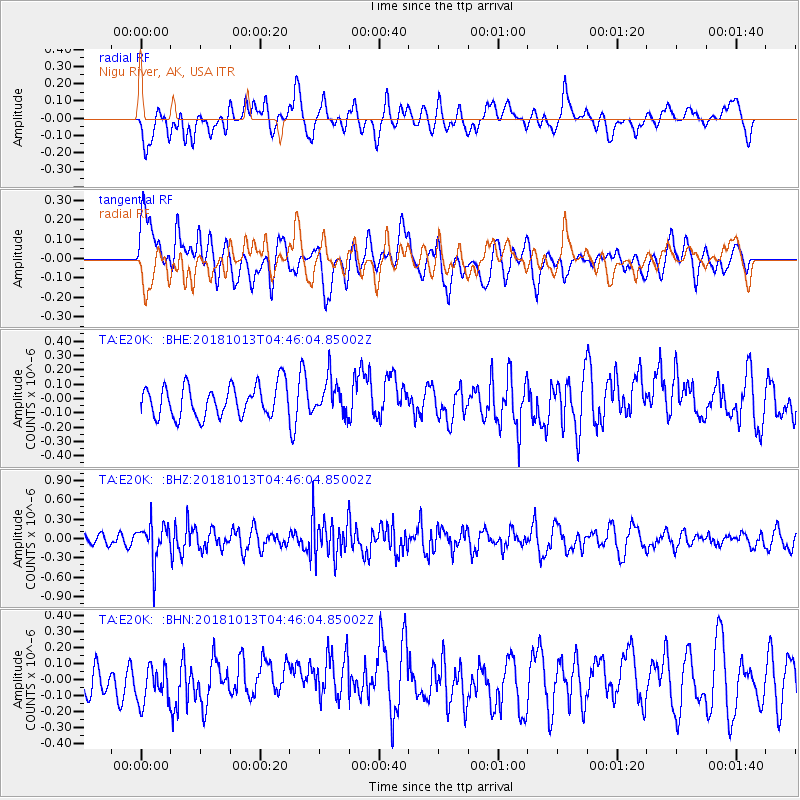
E20K Nigu River, AK, USA - Earthquake Result Viewer
*The percent match for this event was below the threshold and hence no stack was calculated.
| Earthquake location: |
Northern Molucca Sea |
| Earthquake latitude/longitude: |
1.5/125.4 |
| Earthquake time(UTC): |
2018/10/13 (286) 04:34:15 GMT |
| Earthquake Depth: |
106 km |
| Earthquake Magnitude: |
5.2 Mww |
| Earthquake Catalog/Contributor: |
NEIC PDE/us |
|
| Network: |
TA USArray Transportable Network (new EarthScope stations) |
| Station: |
E20K Nigu River, AK, USA |
| Lat/Lon: |
68.26 N/156.19 W |
| Elevation: |
866 m |
|
| Distance: |
84.4 deg |
| Az: |
21.516 deg |
| Baz: |
259.754 deg |
| Ray Param: |
$rayparam |
*The percent match for this event was below the threshold and hence was not used in the summary stack. |
|
| Radial Match: |
43.842808 % |
| Radial Bump: |
400 |
| Transverse Match: |
57.122868 % |
| Transverse Bump: |
400 |
| SOD ConfigId: |
13570011 |
| Insert Time: |
2019-05-01 12:33:15.154 +0000 |
| GWidth: |
2.5 |
| Max Bumps: |
400 |
| Tol: |
0.001 |
|
Signal To Noise
| Channel | StoN | STA | LTA |
| TA:E20K: :BHZ:20181013T04:46:04.85002Z | 3.0949528 | 2.951556E-7 | 9.536675E-8 |
| TA:E20K: :BHN:20181013T04:46:04.85002Z | 1.0175037 | 1.2334257E-7 | 1.2122075E-7 |
| TA:E20K: :BHE:20181013T04:46:04.85002Z | 1.1102542 | 1.2124785E-7 | 1.092073E-7 |
| Arrivals |
| Ps | |
| PpPs | |
| PsPs/PpSs | |


