You are here: Home > Network List > TA - USArray Transportable Network (new EarthScope stations) Stations List
> Station 320A Kipp Ranch, Antelope Well, NM, USA > Earthquake Result Viewer
320A Kipp Ranch, Antelope Well, NM, USA - Earthquake Result Viewer

| Earthquake location: |
Fiji Islands Region |
| Earthquake latitude/longitude: |
-17.3/-177.3 |
| Earthquake time(UTC): |
2008/07/19 (201) 22:39:52 GMT |
| Earthquake Depth: |
391 km |
| Earthquake Magnitude: |
5.9 MB, 6.4 MW, 6.4 MW |
| Earthquake Catalog/Contributor: |
WHDF/NEIC |
|
| Network: |
TA USArray Transportable Network (new EarthScope stations) |
| Station: |
320A Kipp Ranch, Antelope Well, NM, USA |
| Lat/Lon: |
31.34 N/108.53 W |
| Elevation: |
1414 m |
|
| Distance: |
81.8 deg |
| Az: |
53.697 deg |
| Baz: |
244.102 deg |
| Ray Param: |
0.046265144 |
| Estimated Moho Depth: |
10.75 km |
| Estimated Crust Vp/Vs: |
1.60 |
| Assumed Crust Vp: |
6.182 km/s |
| Estimated Crust Vs: |
3.864 km/s |
| Estimated Crust Poisson's Ratio: |
0.18 |
|
| Radial Match: |
87.81977 % |
| Radial Bump: |
400 |
| Transverse Match: |
77.867775 % |
| Transverse Bump: |
400 |
| SOD ConfigId: |
2504 |
| Insert Time: |
2010-03-06 16:50:01.284 +0000 |
| GWidth: |
2.5 |
| Max Bumps: |
400 |
| Tol: |
0.001 |
|
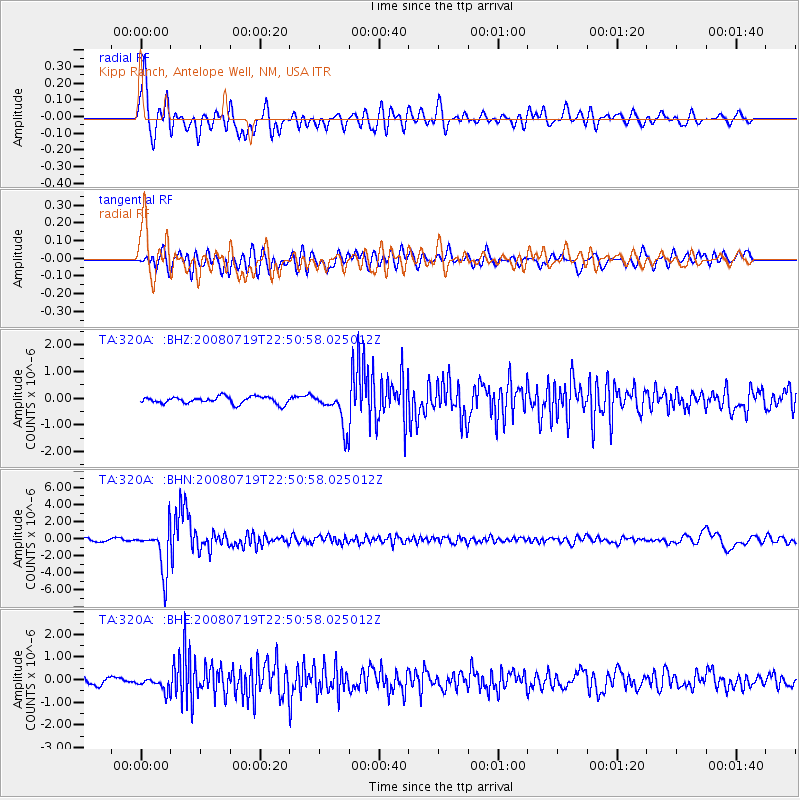
Signal To Noise
| Channel | StoN | STA | LTA |
| TA:320A: :BHN:20080719T22:50:58.025012Z | 14.657374 | 2.5858449E-6 | 1.7641938E-7 |
| TA:320A: :BHE:20080719T22:50:58.025012Z | 2.017003 | 2.9053857E-7 | 1.4404469E-7 |
| TA:320A: :BHZ:20080719T22:50:58.025012Z | 5.1309257 | 6.6828636E-7 | 1.3024675E-7 |
| Arrivals |
| Ps | 1.1 SECOND |
| PpPs | 4.4 SECOND |
| PsPs/PpSs | 5.5 SECOND |


