You are here: Home > Network List > AK - Alaska Regional Network Stations List
> Station TABL Table Mountain, AK, USA > Earthquake Result Viewer
TABL Table Mountain, AK, USA - Earthquake Result Viewer
| Earthquake location: |
Northwest Of Kuril Islands |
| Earthquake latitude/longitude: |
52.7/153.7 |
| Earthquake time(UTC): |
2018/10/13 (286) 11:10:19 GMT |
| Earthquake Depth: |
397 km |
| Earthquake Magnitude: |
6.7 Mi |
| Earthquake Catalog/Contributor: |
NEIC PDE/pt |
|
| Network: |
AK Alaska Regional Network |
| Station: |
TABL Table Mountain, AK, USA |
| Lat/Lon: |
60.44 N/141.14 W |
| Elevation: |
2050 m |
|
| Distance: |
35.3 deg |
| Az: |
51.083 deg |
| Baz: |
287.258 deg |
| Ray Param: |
0.07557504 |
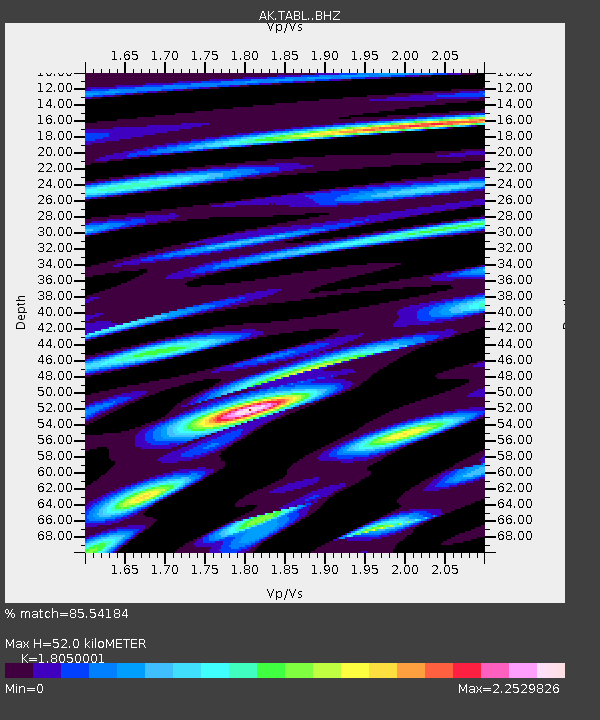
| Estimated Moho Depth: |
52.0 km |
| Estimated Crust Vp/Vs: |
1.81 |
| Assumed Crust Vp: |
6.566 km/s |
| Estimated Crust Vs: |
3.638 km/s |
| Estimated Crust Poisson's Ratio: |
0.28 |
|
| Radial Match: |
85.54184 % |
| Radial Bump: |
400 |
| Transverse Match: |
74.75566 % |
| Transverse Bump: |
400 |
| SOD ConfigId: |
13570011 |
| Insert Time: |
2019-05-01 12:36:31.670 +0000 |
| GWidth: |
2.5 |
| Max Bumps: |
400 |
| Tol: |
0.001 |
|

Signal To Noise
| Channel | StoN | STA | LTA |
| AK:TABL: :BHZ:20181013T11:16:07.967987Z | 30.20028 | 1.6869804E-5 | 5.5859766E-7 |
| AK:TABL: :BHN:20181013T11:16:07.967987Z | 4.084568 | 3.6945694E-6 | 9.0451897E-7 |
| AK:TABL: :BHE:20181013T11:16:07.967987Z | 11.936331 | 7.984754E-6 | 6.689454E-7 |
| Arrivals |
| Ps | 6.9 SECOND |
| PpPs | 21 SECOND |
| PsPs/PpSs | 27 SECOND |


