You are here: Home > Network List > TA - USArray Transportable Network (new EarthScope stations) Stations List
> Station 320A Kipp Ranch, Antelope Well, NM, USA > Earthquake Result Viewer
320A Kipp Ranch, Antelope Well, NM, USA - Earthquake Result Viewer
| Earthquake location: |
Kermadec Islands Region |
| Earthquake latitude/longitude: |
-27.4/-176.3 |
| Earthquake time(UTC): |
2009/02/18 (049) 21:53:45 GMT |
| Earthquake Depth: |
25 km |
| Earthquake Magnitude: |
6.8 MB, 7.2 MS, 6.9 MW, 6.9 MW |
| Earthquake Catalog/Contributor: |
WHDF/NEIC |
|
| Network: |
TA USArray Transportable Network (new EarthScope stations) |
| Station: |
320A Kipp Ranch, Antelope Well, NM, USA |
| Lat/Lon: |
31.34 N/108.53 W |
| Elevation: |
1414 m |
|
| Distance: |
87.1 deg |
| Az: |
52.49 deg |
| Baz: |
235.491 deg |
| Ray Param: |
0.043527152 |
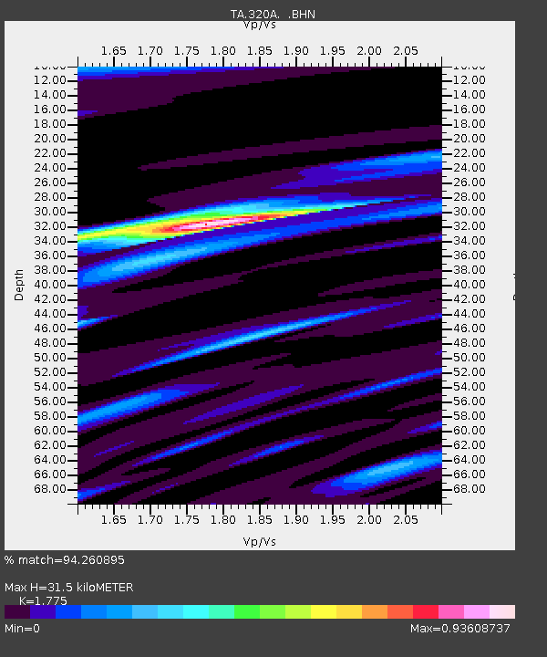
| Estimated Moho Depth: |
31.5 km |
| Estimated Crust Vp/Vs: |
1.77 |
| Assumed Crust Vp: |
6.182 km/s |
| Estimated Crust Vs: |
3.483 km/s |
| Estimated Crust Poisson's Ratio: |
0.27 |
|
| Radial Match: |
94.260895 % |
| Radial Bump: |
348 |
| Transverse Match: |
90.95422 % |
| Transverse Bump: |
400 |
| SOD ConfigId: |
2658 |
| Insert Time: |
2010-03-06 16:50:32.785 +0000 |
| GWidth: |
2.5 |
| Max Bumps: |
400 |
| Tol: |
0.001 |
|

Signal To Noise
| Channel | StoN | STA | LTA |
| TA:320A: :BHN:20090218T22:05:57.350002Z | 24.399658 | 4.363931E-6 | 1.7885215E-7 |
| TA:320A: :BHE:20090218T22:05:57.350002Z | 2.4904697 | 8.608722E-7 | 3.456666E-7 |
| TA:320A: :BHZ:20090218T22:05:57.350002Z | 7.6500087 | 1.5803356E-6 | 2.0657959E-7 |
| Arrivals |
| Ps | 4.0 SECOND |
| PpPs | 14 SECOND |
| PsPs/PpSs | 18 SECOND |


