You are here: Home > Network List > AZ - ANZA Regional Network Stations List
> Station LVA2 AZ.LVA2 > Earthquake Result Viewer
LVA2 AZ.LVA2 - Earthquake Result Viewer
| Earthquake location: |
Northwest Of Kuril Islands |
| Earthquake latitude/longitude: |
52.7/153.7 |
| Earthquake time(UTC): |
2018/10/13 (286) 11:10:19 GMT |
| Earthquake Depth: |
397 km |
| Earthquake Magnitude: |
6.7 Mi |
| Earthquake Catalog/Contributor: |
NEIC PDE/pt |
|
| Network: |
AZ ANZA Regional Network |
| Station: |
LVA2 AZ.LVA2 |
| Lat/Lon: |
33.35 N/116.56 W |
| Elevation: |
1435 m |
|
| Distance: |
64.1 deg |
| Az: |
68.465 deg |
| Baz: |
317.441 deg |
| Ray Param: |
0.057784196 |
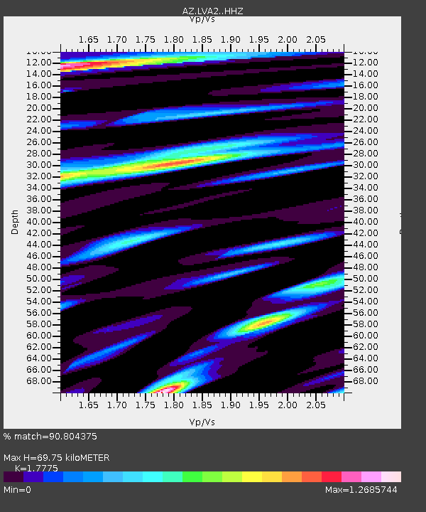
| Estimated Moho Depth: |
69.75 km |
| Estimated Crust Vp/Vs: |
1.78 |
| Assumed Crust Vp: |
6.264 km/s |
| Estimated Crust Vs: |
3.524 km/s |
| Estimated Crust Poisson's Ratio: |
0.27 |
|
| Radial Match: |
90.804375 % |
| Radial Bump: |
400 |
| Transverse Match: |
73.64351 % |
| Transverse Bump: |
400 |
| SOD ConfigId: |
13570011 |
| Insert Time: |
2019-05-01 12:37:13.304 +0000 |
| GWidth: |
2.5 |
| Max Bumps: |
400 |
| Tol: |
0.001 |
|

Signal To Noise
| Channel | StoN | STA | LTA |
| AZ:LVA2: :HHZ:20181013T11:19:40.593018Z | 63.627304 | 7.742072E-6 | 1.2167845E-7 |
| AZ:LVA2: :HHN:20181013T11:19:40.593018Z | 23.053247 | 2.942903E-6 | 1.2765676E-7 |
| AZ:LVA2: :HHE:20181013T11:19:40.593018Z | 15.90295 | 1.9255997E-6 | 1.2108443E-7 |
| Arrivals |
| Ps | 9.0 SECOND |
| PpPs | 30 SECOND |
| PsPs/PpSs | 39 SECOND |


