You are here: Home > Network List > TA - USArray Transportable Network (new EarthScope stations) Stations List
> Station 320A Kipp Ranch, Antelope Well, NM, USA > Earthquake Result Viewer
320A Kipp Ranch, Antelope Well, NM, USA - Earthquake Result Viewer

| Earthquake location: |
Southeast Of Honshu, Japan |
| Earthquake latitude/longitude: |
32.8/140.4 |
| Earthquake time(UTC): |
2009/08/12 (224) 22:48:51 GMT |
| Earthquake Depth: |
53 km |
| Earthquake Magnitude: |
6.2 MB, 6.6 MW, 6.6 MW |
| Earthquake Catalog/Contributor: |
WHDF/NEIC |
|
| Network: |
TA USArray Transportable Network (new EarthScope stations) |
| Station: |
320A Kipp Ranch, Antelope Well, NM, USA |
| Lat/Lon: |
31.34 N/108.53 W |
| Elevation: |
1414 m |
|
| Distance: |
88.8 deg |
| Az: |
52.995 deg |
| Baz: |
308.201 deg |
| Ray Param: |
0.042190876 |
| Estimated Moho Depth: |
63.75 km |
| Estimated Crust Vp/Vs: |
1.64 |
| Assumed Crust Vp: |
6.182 km/s |
| Estimated Crust Vs: |
3.764 km/s |
| Estimated Crust Poisson's Ratio: |
0.21 |
|
| Radial Match: |
85.97251 % |
| Radial Bump: |
400 |
| Transverse Match: |
83.09422 % |
| Transverse Bump: |
400 |
| SOD ConfigId: |
2622 |
| Insert Time: |
2010-03-06 16:50:42.746 +0000 |
| GWidth: |
2.5 |
| Max Bumps: |
400 |
| Tol: |
0.001 |
|
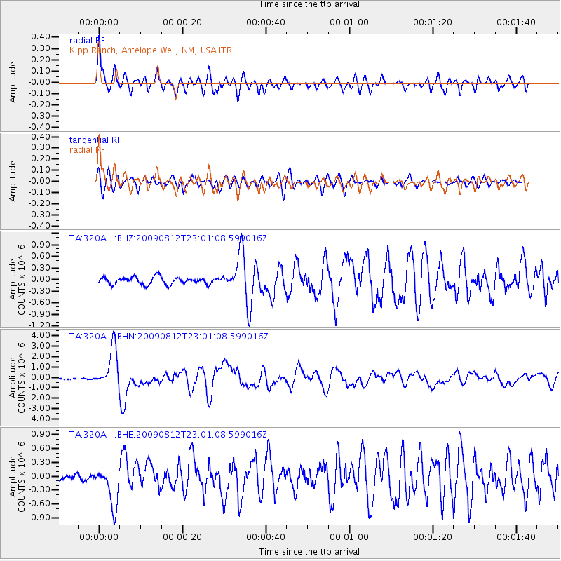
Signal To Noise
| Channel | StoN | STA | LTA |
| TA:320A: :BHN:20090812T23:01:08.599016Z | 28.093712 | 1.983348E-6 | 7.059758E-8 |
| TA:320A: :BHE:20090812T23:01:08.599016Z | 4.7292323 | 4.4033615E-7 | 9.310943E-8 |
| TA:320A: :BHZ:20090812T23:01:08.599016Z | 5.425432 | 5.099031E-7 | 9.398387E-8 |
| Arrivals |
| Ps | 6.8 SECOND |
| PpPs | 27 SECOND |
| PsPs/PpSs | 33 SECOND |


