You are here: Home > Network List > CI - Caltech Regional Seismic Network Stations List
> Station SMM Simmler, CA, USA > Earthquake Result Viewer
SMM Simmler, CA, USA - Earthquake Result Viewer
| Earthquake location: |
Northwest Of Kuril Islands |
| Earthquake latitude/longitude: |
52.7/153.7 |
| Earthquake time(UTC): |
2018/10/13 (286) 11:10:19 GMT |
| Earthquake Depth: |
397 km |
| Earthquake Magnitude: |
6.7 Mi |
| Earthquake Catalog/Contributor: |
NEIC PDE/pt |
|
| Network: |
CI Caltech Regional Seismic Network |
| Station: |
SMM Simmler, CA, USA |
| Lat/Lon: |
35.31 N/120.00 W |
| Elevation: |
599 m |
|
| Distance: |
60.8 deg |
| Az: |
69.282 deg |
| Baz: |
315.89 deg |
| Ray Param: |
0.05991846 |
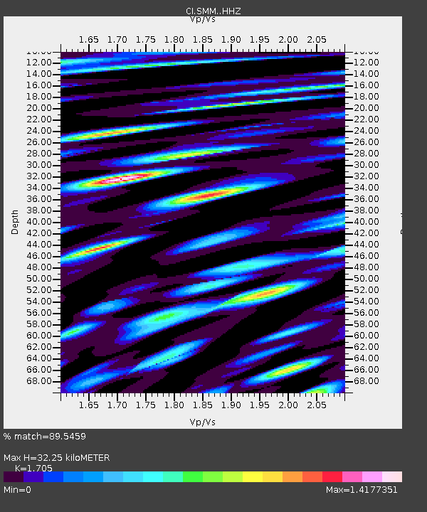
| Estimated Moho Depth: |
32.25 km |
| Estimated Crust Vp/Vs: |
1.71 |
| Assumed Crust Vp: |
6.1 km/s |
| Estimated Crust Vs: |
3.578 km/s |
| Estimated Crust Poisson's Ratio: |
0.24 |
|
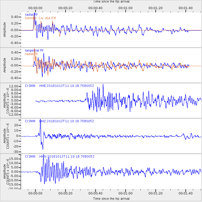
| Radial Match: |
89.5459 % |
| Radial Bump: |
400 |
| Transverse Match: |
86.7426 % |
| Transverse Bump: |
400 |
| SOD ConfigId: |
13570011 |
| Insert Time: |
2019-05-01 12:39:30.340 +0000 |
| GWidth: |
2.5 |
| Max Bumps: |
400 |
| Tol: |
0.001 |
|
Signal To Noise
| Channel | StoN | STA | LTA |
| CI:SMM: :HHZ:20181013T11:19:18.768005Z | 72.33035 | 1.16712245E-5 | 1.6135998E-7 |
| CI:SMM: :HHN:20181013T11:19:18.768005Z | 13.626962 | 3.623186E-6 | 2.6588364E-7 |
| CI:SMM: :HHE:20181013T11:19:18.768005Z | 6.912671 | 2.5493573E-6 | 3.6879484E-7 |
| Arrivals |
| Ps | 3.9 SECOND |
| PpPs | 14 SECOND |
| PsPs/PpSs | 18 SECOND |


