You are here: Home > Network List > TA - USArray Transportable Network (new EarthScope stations) Stations List
> Station 320A Kipp Ranch, Antelope Well, NM, USA > Earthquake Result Viewer
320A Kipp Ranch, Antelope Well, NM, USA - Earthquake Result Viewer
| Earthquake location: |
Andreanof Islands, Aleutian Is. |
| Earthquake latitude/longitude: |
51.9/-179.2 |
| Earthquake time(UTC): |
2008/04/16 (107) 05:54:19 GMT |
| Earthquake Depth: |
13 km |
| Earthquake Magnitude: |
6.1 MB, 6.5 MS, 6.6 MW, 6.6 MW |
| Earthquake Catalog/Contributor: |
WHDF/NEIC |
|
| Network: |
TA USArray Transportable Network (new EarthScope stations) |
| Station: |
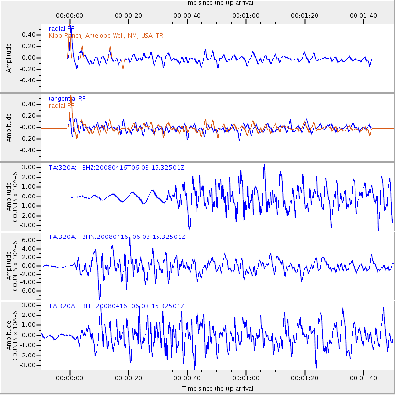
320A Kipp Ranch, Antelope Well, NM, USA |
| Lat/Lon: |
31.34 N/108.53 W |
| Elevation: |
1414 m |
|
| Distance: |
54.4 deg |
| Az: |
83.065 deg |
| Baz: |
314.014 deg |
| Ray Param: |
0.065457486 |
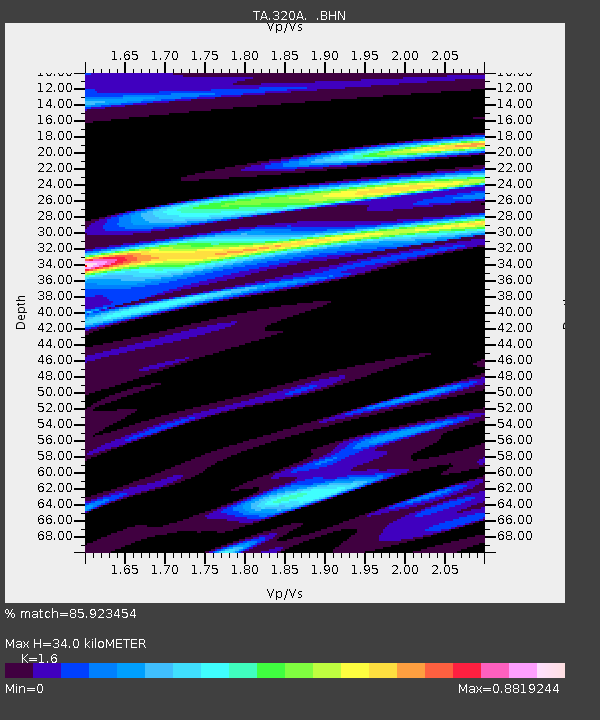
| Estimated Moho Depth: |
34.0 km |
| Estimated Crust Vp/Vs: |
1.60 |
| Assumed Crust Vp: |
6.182 km/s |
| Estimated Crust Vs: |
3.864 km/s |
| Estimated Crust Poisson's Ratio: |
0.18 |
|
| Radial Match: |
85.923454 % |
| Radial Bump: |
400 |
| Transverse Match: |
80.69955 % |
| Transverse Bump: |
400 |
| SOD ConfigId: |
2504 |
| Insert Time: |
2010-03-06 16:51:14.766 +0000 |
| GWidth: |
2.5 |
| Max Bumps: |
400 |
| Tol: |
0.001 |
|
Signal To Noise
| Channel | StoN | STA | LTA |
| TA:320A: :BHN:20080416T06:03:15.32501Z | 5.675577 | 9.5126023E-7 | 1.676059E-7 |
| TA:320A: :BHE:20080416T06:03:15.32501Z | 1.6316705 | 3.4470168E-7 | 2.1125692E-7 |
| TA:320A: :BHZ:20080416T06:03:15.32501Z | 1.4690993 | 3.5143427E-7 | 2.392175E-7 |
| Arrivals |
| Ps | 3.5 SECOND |
| PpPs | 14 SECOND |
| PsPs/PpSs | 17 SECOND |


