You are here: Home > Network List > TA - USArray Transportable Network (new EarthScope stations) Stations List
> Station 320A Kipp Ranch, Antelope Well, NM, USA > Earthquake Result Viewer
320A Kipp Ranch, Antelope Well, NM, USA - Earthquake Result Viewer

| Earthquake location: |
Northern Algeria |
| Earthquake latitude/longitude: |
35.9/-0.7 |
| Earthquake time(UTC): |
2008/06/06 (158) 20:02:56 GMT |
| Earthquake Depth: |
4.0 km |
| Earthquake Magnitude: |
5.5 MB, 5.3 MS, 5.5 MW, 5.5 MW |
| Earthquake Catalog/Contributor: |
WHDF/NEIC |
|
| Network: |
TA USArray Transportable Network (new EarthScope stations) |
| Station: |
320A Kipp Ranch, Antelope Well, NM, USA |
| Lat/Lon: |
31.34 N/108.53 W |
| Elevation: |
1414 m |
|
| Distance: |
84.9 deg |
| Az: |
305.153 deg |
| Baz: |
50.892 deg |
| Ray Param: |
0.045156315 |
| Estimated Moho Depth: |
57.5 km |
| Estimated Crust Vp/Vs: |
2.05 |
| Assumed Crust Vp: |
6.182 km/s |
| Estimated Crust Vs: |
3.016 km/s |
| Estimated Crust Poisson's Ratio: |
0.34 |
|
| Radial Match: |
88.602905 % |
| Radial Bump: |
400 |
| Transverse Match: |
79.968445 % |
| Transverse Bump: |
400 |
| SOD ConfigId: |
2504 |
| Insert Time: |
2010-03-06 16:51:18.532 +0000 |
| GWidth: |
2.5 |
| Max Bumps: |
400 |
| Tol: |
0.001 |
|
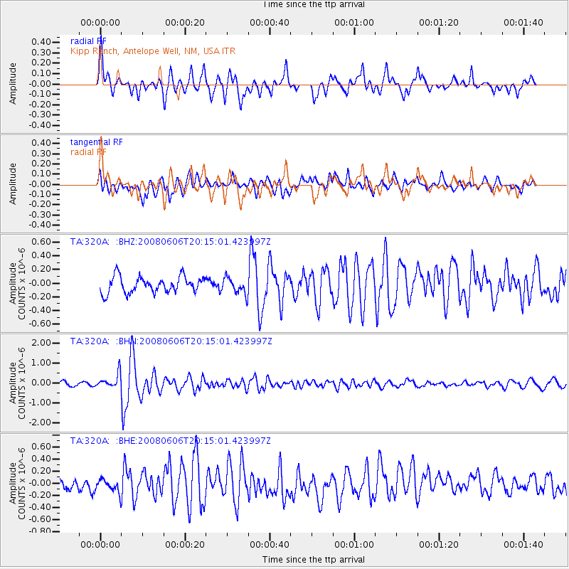
Signal To Noise
| Channel | StoN | STA | LTA |
| TA:320A: :BHN:20080606T20:15:01.423997Z | 2.9709024 | 3.6460267E-7 | 1.2272456E-7 |
| TA:320A: :BHE:20080606T20:15:01.423997Z | 1.0712668 | 1.06766784E-7 | 9.966405E-8 |
| TA:320A: :BHZ:20080606T20:15:01.423997Z | 1.025463 | 1.2052415E-7 | 1.1753144E-7 |
| Arrivals |
| Ps | 10.0 SECOND |
| PpPs | 28 SECOND |
| PsPs/PpSs | 38 SECOND |


