You are here: Home > Network List > CN - Canadian National Seismograph Network Stations List
> Station YUK7 Dusty Glacier, YT, CA > Earthquake Result Viewer
YUK7 Dusty Glacier, YT, CA - Earthquake Result Viewer
| Earthquake location: |
Northwest Of Kuril Islands |
| Earthquake latitude/longitude: |
52.7/153.7 |
| Earthquake time(UTC): |
2018/10/13 (286) 11:10:19 GMT |
| Earthquake Depth: |
397 km |
| Earthquake Magnitude: |
6.7 Mi |
| Earthquake Catalog/Contributor: |
NEIC PDE/pt |
|
| Network: |
CN Canadian National Seismograph Network |
| Station: |
YUK7 Dusty Glacier, YT, CA |
| Lat/Lon: |
60.53 N/138.14 W |
| Elevation: |
1992 m |
|
| Distance: |
36.7 deg |
| Az: |
50.147 deg |
| Baz: |
289.112 deg |
| Ray Param: |
0.0748066 |
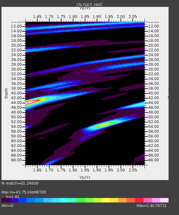
| Estimated Moho Depth: |
43.75 km |
| Estimated Crust Vp/Vs: |
1.61 |
| Assumed Crust Vp: |
6.566 km/s |
| Estimated Crust Vs: |
4.078 km/s |
| Estimated Crust Poisson's Ratio: |
0.19 |
|
| Radial Match: |
81.24838 % |
| Radial Bump: |
400 |
| Transverse Match: |
59.2341 % |
| Transverse Bump: |
400 |
| SOD ConfigId: |
13570011 |
| Insert Time: |
2019-05-01 12:40:36.036 +0000 |
| GWidth: |
2.5 |
| Max Bumps: |
400 |
| Tol: |
0.001 |
|

Signal To Noise
| Channel | StoN | STA | LTA |
| CN:YUK7: :HHZ:20181013T11:16:19.420013Z | 48.65146 | 8.772238E-6 | 1.8030782E-7 |
| CN:YUK7: :HHN:20181013T11:16:19.420013Z | 1.7824038 | 2.17202E-6 | 1.2185903E-6 |
| CN:YUK7: :HHE:20181013T11:16:19.420013Z | 4.249957 | 5.467047E-6 | 1.2863769E-6 |
| Arrivals |
| Ps | 4.4 SECOND |
| PpPs | 16 SECOND |
| PsPs/PpSs | 20 SECOND |


