You are here: Home > Network List > G - GEOSCOPE Stations List
> Station ATD Arta Cave - Arta, Republic of Djibouti > Earthquake Result Viewer
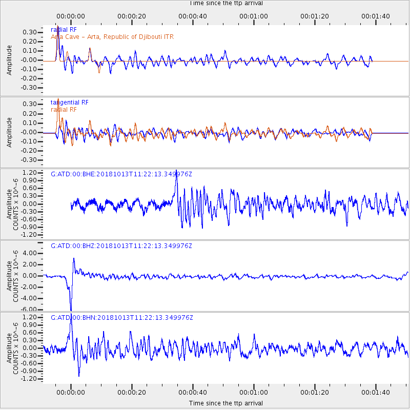
ATD Arta Cave - Arta, Republic of Djibouti - Earthquake Result Viewer
*The percent match for this event was below the threshold and hence no stack was calculated.
| Earthquake location: |
Northwest Of Kuril Islands |
| Earthquake latitude/longitude: |
52.7/153.7 |
| Earthquake time(UTC): |
2018/10/13 (286) 11:10:19 GMT |
| Earthquake Depth: |
397 km |
| Earthquake Magnitude: |
6.7 Mi |
| Earthquake Catalog/Contributor: |
NEIC PDE/pt |
|
| Network: |
G GEOSCOPE |
| Station: |
ATD Arta Cave - Arta, Republic of Djibouti |
| Lat/Lon: |
11.53 N/42.85 E |
| Elevation: |
610 m |
|
| Distance: |
93.1 deg |
| Az: |
293.451 deg |
| Baz: |
34.727 deg |
| Ray Param: |
$rayparam |
*The percent match for this event was below the threshold and hence was not used in the summary stack. |
|
| Radial Match: |
79.27205 % |
| Radial Bump: |
400 |
| Transverse Match: |
72.4181 % |
| Transverse Bump: |
400 |
| SOD ConfigId: |
13570011 |
| Insert Time: |
2019-05-01 12:40:53.823 +0000 |
| GWidth: |
2.5 |
| Max Bumps: |
400 |
| Tol: |
0.001 |
|
Signal To Noise
| Channel | StoN | STA | LTA |
| G:ATD:00:BHZ:20181013T11:22:13.349976Z | 13.820693 | 2.2277636E-6 | 1.6119044E-7 |
| G:ATD:00:BHN:20181013T11:22:13.349976Z | 5.940631 | 5.757546E-7 | 9.69181E-8 |
| G:ATD:00:BHE:20181013T11:22:13.349976Z | 4.1259217 | 5.8215795E-7 | 1.4109767E-7 |
| Arrivals |
| Ps | |
| PpPs | |
| PsPs/PpSs | |


