You are here: Home > Network List > IC - New China Digital Seismograph Network Stations List
> Station WMQ Urumqi, Xinjiang Province, China > Earthquake Result Viewer
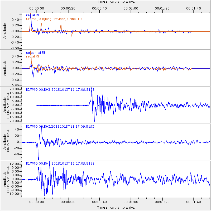
WMQ Urumqi, Xinjiang Province, China - Earthquake Result Viewer
*The percent match for this event was below the threshold and hence no stack was calculated.
| Earthquake location: |
Northwest Of Kuril Islands |
| Earthquake latitude/longitude: |
52.7/153.7 |
| Earthquake time(UTC): |
2018/10/13 (286) 11:10:19 GMT |
| Earthquake Depth: |
397 km |
| Earthquake Magnitude: |
6.7 Mi |
| Earthquake Catalog/Contributor: |
NEIC PDE/pt |
|
| Network: |
IC New China Digital Seismograph Network |
| Station: |
WMQ Urumqi, Xinjiang Province, China |
| Lat/Lon: |
43.81 N/87.70 E |
| Elevation: |
850 m |
|
| Distance: |
43.4 deg |
| Az: |
285.708 deg |
| Baz: |
54.028 deg |
| Ray Param: |
$rayparam |
*The percent match for this event was below the threshold and hence was not used in the summary stack. |
|
| Radial Match: |
88.38444 % |
| Radial Bump: |
400 |
| Transverse Match: |
78.519226 % |
| Transverse Bump: |
400 |
| SOD ConfigId: |
13570011 |
| Insert Time: |
2019-05-01 12:41:45.418 +0000 |
| GWidth: |
2.5 |
| Max Bumps: |
400 |
| Tol: |
0.001 |
|
Signal To Noise
| Channel | StoN | STA | LTA |
| IC:WMQ:00:BHZ:20181013T11:17:09.819Z | 147.33113 | 2.2071024E-5 | 1.4980557E-7 |
| IC:WMQ:00:BH1:20181013T11:17:09.819Z | 43.187553 | 5.437427E-6 | 1.2590263E-7 |
| IC:WMQ:00:BH2:20181013T11:17:09.819Z | 79.00619 | 9.959788E-6 | 1.260634E-7 |
| Arrivals |
| Ps | |
| PpPs | |
| PsPs/PpSs | |


