You are here: Home > Network List > IU - Global Seismograph Network (GSN - IRIS/USGS) Stations List
> Station GRFO Grafenberg, Germany > Earthquake Result Viewer
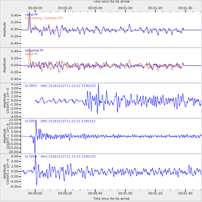
GRFO Grafenberg, Germany - Earthquake Result Viewer
*The percent match for this event was below the threshold and hence no stack was calculated.
| Earthquake location: |
Northwest Of Kuril Islands |
| Earthquake latitude/longitude: |
52.7/153.7 |
| Earthquake time(UTC): |
2018/10/13 (286) 11:10:19 GMT |
| Earthquake Depth: |
397 km |
| Earthquake Magnitude: |
6.7 Mi |
| Earthquake Catalog/Contributor: |
NEIC PDE/pt |
|
| Network: |
IU Global Seismograph Network (GSN - IRIS/USGS) |
| Station: |
GRFO Grafenberg, Germany |
| Lat/Lon: |
49.69 N/11.22 E |
| Elevation: |
384 m |
|
| Distance: |
73.1 deg |
| Az: |
335.573 deg |
| Baz: |
22.801 deg |
| Ray Param: |
$rayparam |
*The percent match for this event was below the threshold and hence was not used in the summary stack. |
|
| Radial Match: |
84.613266 % |
| Radial Bump: |
361 |
| Transverse Match: |
74.867195 % |
| Transverse Bump: |
400 |
| SOD ConfigId: |
13570011 |
| Insert Time: |
2019-05-01 12:42:02.332 +0000 |
| GWidth: |
2.5 |
| Max Bumps: |
400 |
| Tol: |
0.001 |
|
Signal To Noise
| Channel | StoN | STA | LTA |
| IU:GRFO: :HHZ:20181013T11:20:32.528015Z | 25.40414 | 8.23582E-6 | 3.2419206E-7 |
| IU:GRFO: :HH1:20181013T11:20:32.528015Z | 8.4373455 | 2.7159306E-6 | 3.2189396E-7 |
| IU:GRFO: :HH2:20181013T11:20:32.528015Z | 3.7741494 | 1.2690152E-6 | 3.3623874E-7 |
| Arrivals |
| Ps | |
| PpPs | |
| PsPs/PpSs | |


