You are here: Home > Network List > LB - Leo Brady Network Stations List
> Station MVU Marysvale, Piute County, Utah, USA > Earthquake Result Viewer
MVU Marysvale, Piute County, Utah, USA - Earthquake Result Viewer
| Earthquake location: |
Northwest Of Kuril Islands |
| Earthquake latitude/longitude: |
52.7/153.7 |
| Earthquake time(UTC): |
2018/10/13 (286) 11:10:19 GMT |
| Earthquake Depth: |
397 km |
| Earthquake Magnitude: |
6.7 Mi |
| Earthquake Catalog/Contributor: |
NEIC PDE/pt |
|
| Network: |
LB Leo Brady Network |
| Station: |
MVU Marysvale, Piute County, Utah, USA |
| Lat/Lon: |
38.50 N/112.21 W |
| Elevation: |
2239 m |
|
| Distance: |
62.8 deg |
| Az: |
61.665 deg |
| Baz: |
316.942 deg |
| Ray Param: |
0.05865737 |
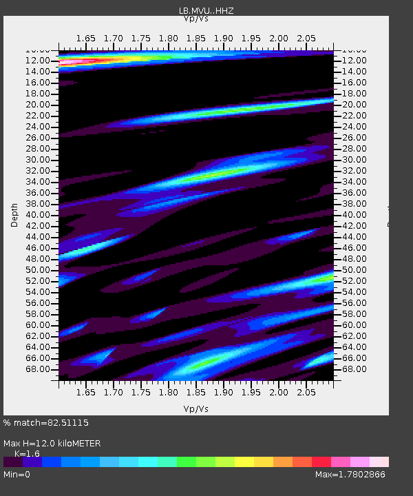
| Estimated Moho Depth: |
12.0 km |
| Estimated Crust Vp/Vs: |
1.60 |
| Assumed Crust Vp: |
6.276 km/s |
| Estimated Crust Vs: |
3.922 km/s |
| Estimated Crust Poisson's Ratio: |
0.18 |
|
| Radial Match: |
82.51115 % |
| Radial Bump: |
400 |
| Transverse Match: |
69.022026 % |
| Transverse Bump: |
400 |
| SOD ConfigId: |
13570011 |
| Insert Time: |
2019-05-01 12:42:37.466 +0000 |
| GWidth: |
2.5 |
| Max Bumps: |
400 |
| Tol: |
0.001 |
|

Signal To Noise
| Channel | StoN | STA | LTA |
| LB:MVU: :HHZ:20181013T11:19:31.607971Z | 64.75446 | 6.1940846E-6 | 9.565495E-8 |
| LB:MVU: :HHN:20181013T11:19:31.607971Z | 7.5978594 | 1.8081585E-6 | 2.379826E-7 |
| LB:MVU: :HHE:20181013T11:19:31.607971Z | 11.471774 | 1.7149354E-6 | 1.4949173E-7 |
| Arrivals |
| Ps | 1.2 SECOND |
| PpPs | 4.8 SECOND |
| PsPs/PpSs | 6.0 SECOND |


