You are here: Home > Network List > LD - Lamont-Doherty Cooperative Seismographic Network Stations List
> Station MVL Millersville University, PA > Earthquake Result Viewer
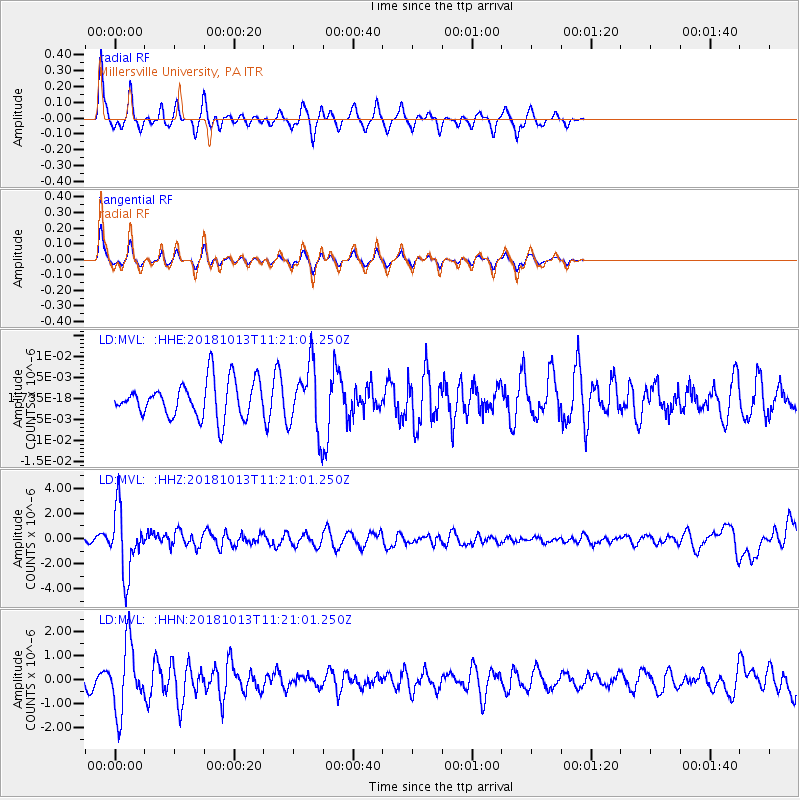
MVL Millersville University, PA - Earthquake Result Viewer
*The percent match for this event was below the threshold and hence no stack was calculated.
| Earthquake location: |
Northwest Of Kuril Islands |
| Earthquake latitude/longitude: |
52.7/153.7 |
| Earthquake time(UTC): |
2018/10/13 (286) 11:10:19 GMT |
| Earthquake Depth: |
397 km |
| Earthquake Magnitude: |
6.7 Mi |
| Earthquake Catalog/Contributor: |
NEIC PDE/pt |
|
| Network: |
LD Lamont-Doherty Cooperative Seismographic Network |
| Station: |
MVL Millersville University, PA |
| Lat/Lon: |
40.00 N/76.35 W |
| Elevation: |
91 m |
|
| Distance: |
78.0 deg |
| Az: |
36.998 deg |
| Baz: |
331.525 deg |
| Ray Param: |
$rayparam |
*The percent match for this event was below the threshold and hence was not used in the summary stack. |
|
| Radial Match: |
74.20534 % |
| Radial Bump: |
271 |
| Transverse Match: |
73.95186 % |
| Transverse Bump: |
274 |
| SOD ConfigId: |
13570011 |
| Insert Time: |
2019-05-01 12:42:51.809 +0000 |
| GWidth: |
2.5 |
| Max Bumps: |
400 |
| Tol: |
0.001 |
|
Signal To Noise
| Channel | StoN | STA | LTA |
| LD:MVL: :HHZ:20181013T11:21:01.250Z | 11.241014 | 2.5427753E-6 | 2.2620515E-7 |
| LD:MVL: :HHN:20181013T11:21:01.250Z | 4.2590103 | 1.3779207E-6 | 3.2353074E-7 |
| LD:MVL: :HHE:20181013T11:21:01.250Z | 2.009735 | 9.561366E-9 | 4.7575255E-9 |
| Arrivals |
| Ps | |
| PpPs | |
| PsPs/PpSs | |


