You are here: Home > Network List > G - GEOSCOPE Stations List
> Station MPG Montagne des Peres, French Guyana > Earthquake Result Viewer
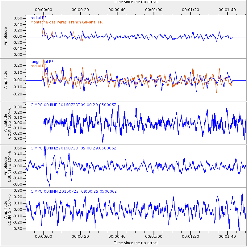
MPG Montagne des Peres, French Guyana - Earthquake Result Viewer
*The percent match for this event was below the threshold and hence no stack was calculated.
| Earthquake location: |
Off Coast Of Guerrero, Mexico |
| Earthquake latitude/longitude: |
14.9/-103.5 |
| Earthquake time(UTC): |
2016/07/23 (205) 08:52:02 GMT |
| Earthquake Depth: |
45 km |
| Earthquake Magnitude: |
5.5 MB |
| Earthquake Catalog/Contributor: |
NEIC PDE/NEIC COMCAT |
|
| Network: |
G GEOSCOPE |
| Station: |
MPG Montagne des Peres, French Guyana |
| Lat/Lon: |
5.11 N/52.64 W |
| Elevation: |
147 m |
|
| Distance: |
50.9 deg |
| Az: |
95.51 deg |
| Baz: |
284.912 deg |
| Ray Param: |
$rayparam |
*The percent match for this event was below the threshold and hence was not used in the summary stack. |
|
| Radial Match: |
52.069283 % |
| Radial Bump: |
400 |
| Transverse Match: |
61.122467 % |
| Transverse Bump: |
400 |
| SOD ConfigId: |
1634031 |
| Insert Time: |
2016-08-17 08:11:43.442 +0000 |
| GWidth: |
2.5 |
| Max Bumps: |
400 |
| Tol: |
0.001 |
|
Signal To Noise
| Channel | StoN | STA | LTA |
| G:MPG:00:BHZ:20160723T09:00:29.050006Z | 4.170082 | 3.8305203E-7 | 9.185719E-8 |
| G:MPG:00:BHN:20160723T09:00:29.050006Z | 0.9807385 | 8.346232E-8 | 8.51015E-8 |
| G:MPG:00:BHE:20160723T09:00:29.050006Z | 1.8478565 | 1.5923048E-7 | 8.617037E-8 |
| Arrivals |
| Ps | |
| PpPs | |
| PsPs/PpSs | |


