You are here: Home > Network List > TS - TERRAscope (Southern California Seismic Network) Stations List
> Station BAR Barrett Dam, California, USA > Earthquake Result Viewer
BAR Barrett Dam, California, USA - Earthquake Result Viewer
| Earthquake location: |
Kuril Islands |
| Earthquake latitude/longitude: |
43.7/147.6 |
| Earthquake time(UTC): |
1996/05/07 (128) 23:20:00 GMT |
| Earthquake Depth: |
54 km |
| Earthquake Magnitude: |
6.2 MB, 5.6 MS, 6.2 UNKNOWN, 5.2 MS |
| Earthquake Catalog/Contributor: |
WHDF/NEIC |
|
| Network: |
TS TERRAscope (Southern California Seismic Network) |
| Station: |
BAR Barrett Dam, California, USA |
| Lat/Lon: |
32.68 N/116.67 W |
| Elevation: |
548 m |
|
| Distance: |
72.0 deg |
| Az: |
61.925 deg |
| Baz: |
310.649 deg |
| Ray Param: |
0.05384435 |
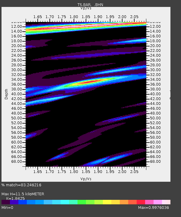
| Estimated Moho Depth: |
11.5 km |
| Estimated Crust Vp/Vs: |
1.84 |
| Assumed Crust Vp: |
6.264 km/s |
| Estimated Crust Vs: |
3.4 km/s |
| Estimated Crust Poisson's Ratio: |
0.29 |
|
| Radial Match: |
83.246216 % |
| Radial Bump: |
400 |
| Transverse Match: |
65.39257 % |
| Transverse Bump: |
400 |
| SOD ConfigId: |
6273 |
| Insert Time: |
2010-02-26 13:58:46.939 +0000 |
| GWidth: |
2.5 |
| Max Bumps: |
400 |
| Tol: |
0.001 |
|
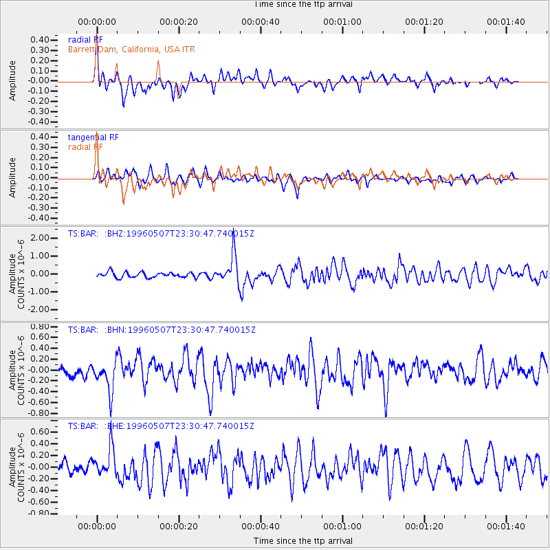
Signal To Noise
| Channel | StoN | STA | LTA |
| TS:BAR: :BHN:19960507T23:30:47.740015Z | 2.4646409 | 3.0243976E-7 | 1.227115E-7 |
| TS:BAR: :BHE:19960507T23:30:47.740015Z | 2.387943 | 2.5645352E-7 | 1.0739515E-7 |
| TS:BAR: :BHZ:19960507T23:30:47.740015Z | 5.766743 | 8.252166E-7 | 1.4309924E-7 |
| Arrivals |
| Ps | 1.6 SECOND |
| PpPs | 5.1 SECOND |
| PsPs/PpSs | 6.7 SECOND |


