You are here: Home > Network List > NN - Western Great Basin/Eastern Sierra Nevada Stations List
> Station MZPB Montezuma,NV,USA analog reactivation > Earthquake Result Viewer
MZPB Montezuma,NV,USA analog reactivation - Earthquake Result Viewer
| Earthquake location: |
Northwest Of Kuril Islands |
| Earthquake latitude/longitude: |
52.7/153.7 |
| Earthquake time(UTC): |
2018/10/13 (286) 11:10:19 GMT |
| Earthquake Depth: |
397 km |
| Earthquake Magnitude: |
6.7 Mi |
| Earthquake Catalog/Contributor: |
NEIC PDE/pt |
|
| Network: |
NN Western Great Basin/Eastern Sierra Nevada |
| Station: |
MZPB Montezuma,NV,USA analog reactivation |
| Lat/Lon: |
37.70 N/117.38 W |
| Elevation: |
2371 m |
|
| Distance: |
60.5 deg |
| Az: |
65.645 deg |
| Baz: |
315.654 deg |
| Ray Param: |
0.060068183 |
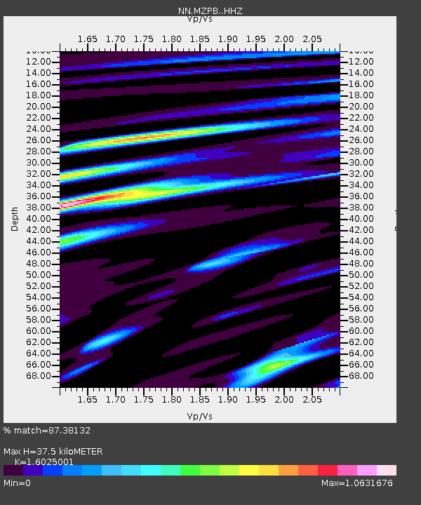
| Estimated Moho Depth: |
37.5 km |
| Estimated Crust Vp/Vs: |
1.60 |
| Assumed Crust Vp: |
6.279 km/s |
| Estimated Crust Vs: |
3.918 km/s |
| Estimated Crust Poisson's Ratio: |
0.18 |
|
| Radial Match: |
87.38132 % |
| Radial Bump: |
386 |
| Transverse Match: |
78.97371 % |
| Transverse Bump: |
400 |
| SOD ConfigId: |
13570011 |
| Insert Time: |
2019-05-01 12:45:26.579 +0000 |
| GWidth: |
2.5 |
| Max Bumps: |
400 |
| Tol: |
0.001 |
|

Signal To Noise
| Channel | StoN | STA | LTA |
| NN:MZPB: :HHZ:20181013T11:19:17.090027Z | 51.452133 | 3.8650346E-6 | 7.511903E-8 |
| NN:MZPB: :HHN:20181013T11:19:17.090027Z | 27.71321 | 1.1254907E-6 | 4.0612072E-8 |
| NN:MZPB: :HHE:20181013T11:19:17.090027Z | 16.301737 | 1.3610031E-6 | 8.3488224E-8 |
| Arrivals |
| Ps | 3.8 SECOND |
| PpPs | 15 SECOND |
| PsPs/PpSs | 19 SECOND |


